Categories
Rowing the Grand Canyon

Lee’s Ferry, River Mile Zero: Arrival and Set-up

1280px-Vermillion_Cliffs_Arizona_Erik_Voss_IMG_3912Vermillion Cliffs (wikipedia photo)

On Sunday, June 15, 2014, Tania and I got into a van with a driver and 10 other people and headed north from Flagstaff. We followed a five-ton truck that carried four others from our party, plus enough food and gear to sustain 16 people for 16 days. We were leaving behind grocery stores, air conditioning, e-mail, and cell phones. We were expecting rattlesnakes, scorpions, extreme heat, high cliffs, and world-famous rapids. But it would all be worth the trouble, because we were rowing the Grand Canyon.

0615TruckI don’t want to over-sell this. We didn’t live on flour, coffee, bacon, and wild game, as John Wesley Powell’s party did when it went down the river in the summer of 1869. Unlike Powell, we carried generous amounts of beer and wine, a four-burner propane stove, and coolers that could keep fresh vegetables edible for two weeks. We had Dutch ovens for baking bread and cake, sleeping cots, camp chairs, and a

100_4599satellite phone that would summon a helicopter if anything went seriously wrong. About 35,000 people float through the Grand Canyon every year. There’s a system.

But still. Most of those 35,000 don’t go on the full 226-mile trip from Lee’s Ferry to Diamond Creek, and most of the 226-milers rely on professional guides, paying upwards of $4,000 for a seat on a 30-foot motorized raft. Only about one-fifth of rafters go on “noncommercial” trips like ours, and we weren’t using motors, either. Our trip was cheaper but also harder because we did the work ourselves.

The trip leader, Pete Kirchner, won a permit in the National Park Service’s (NPS) annual weighted lottery in February, 2013. He and his wife, Christie Kroll, contracted with Professional River Outfitters (PRO) in Flagstaff to rent the rafts and equipment, buy and pack the food, and drive everything (and us) to and from the river. Pete and Christie recruited a great crew. And Pete also cloistered himself at home in the weeks leading up to the trip, forsaking outdoor exercise and washing his hands compulsively, because if he was injured or ill and unable to make it to Lee’s Ferry on June 16, the strict NPS rules would probably not allow the trip to happen. I think we all felt that getting to Lee’s Ferry was a milestone, but for Pete and Christie, it was an especially big one.

US Highway 89 north of Flagstaff cuts through an arid plain with mountains in the far distance, and after an hour of looking at that kind of scenery, my mind started to wander. I grew up in a small town in south Florida, which is as flat as Nebraska. There was not much for a kid to do in the summer, so I would check out huge stacks of books from the library to amuse myself. One day I brought home a book about geology, and I opened it to a color photograph of the Grand Canyon.

The book said that the river often flowed more than a mile below the rim. As an eight-year-old, a three-foot drainage ditch seemed deep to me. But a mile? How is this possible? I needed to see this place. And I did – I glimpsed the Canyon from the South Rim on a road trip at age 15. At 26, I hiked down from the South Rim and slept on the river. And over the next three decades, I spent a lot of days blissfully wandering around in desert canyons. Yet I had not done what that eight-year-old had dreamed of doing, until now.

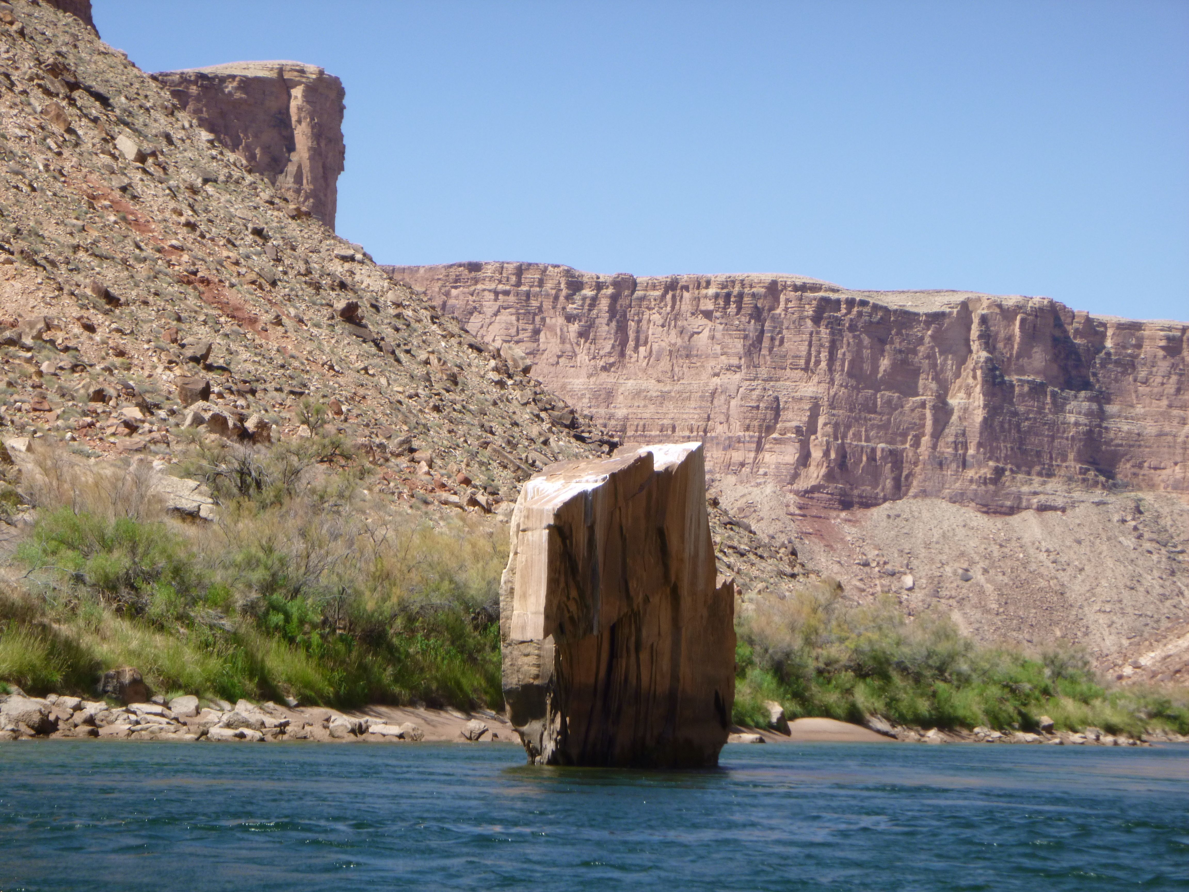
I saw the Vermillion Cliffs when the van was about 25 miles away. Someone in the van said that they were on the far side of the river. They grew closer while I stared at them, their colors changing with the angle of the sun. Then we went around a bend and down an incline, and there was the river, a blue-green streak amid the reds and grays. The van broke into applause as we crossed the Navajo Bridge. A few miles later, we reached the boat ramp at Lee’s Ferry.

Navajo Bridge (Wikipedia)

Passing_Navajo_bridgeMost summer visitors to Arizona’s low desert live inside an air-conditioned envelope. The daytime high temperature in the Canyon in June reliably exceeds 100 degrees, and the humidity is usually very low (around 10 percent) before the summer “monsoon season” starts. When we got out of the van around 3pm, it was cloudless with a steady hot wind. It was perfect weather for drying stuff — fruit, skin, eyeballs,what have you. And we had three hours to unload the truck, inflate the rafts, set up their internal frames, pack them with our gear, and launch. The work was so hot and the sun was so strong that long pants and sleeves, a hat, and sunglasses were safety equipment. Wearing artificial fibers instead of cotton was also important, because 0615InflatingBoatsthey made it easier to jump into the river to cool off. With nylon, your clothes would feel like they had been pulled fresh out of the dryer ten minutes after they were soaking wet.

(above) Tania and Christie inflating the rafts; (below) rigging at Lee’s Ferry boat ramp

0614RiggingOverview
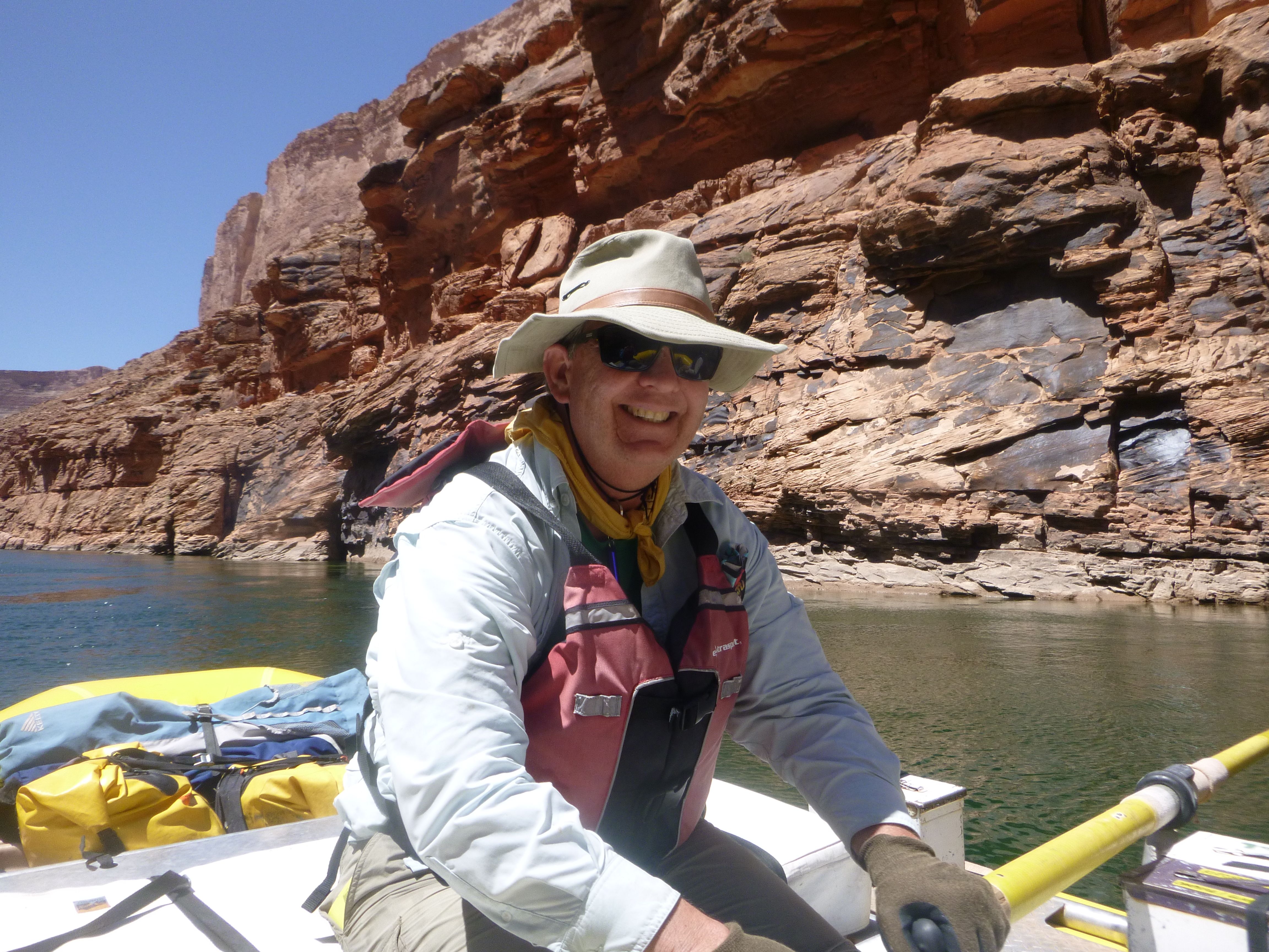
We were rigging six neoprene rafts — five yellow 18-footers, and a blue one that measured 16 feet. Each raft weighed more than half a ton when it was loaded. The frames had compartments for the coolers and large steel boxes, plus straps for the rest of the stuff. Everything had to be secured, in case the rafts ever flipped (as one eventually did).   Clothing, personal items, and other things that needed to be waterproof were loaded into rubbery dry bags or metal ammunition boxes. The work was focused but not frantic, as PRO manager Beth Roeser and the driver, her spouse Bryant, stepped in whenever questions or disagreements came up. PRO has been doing this since 1983, and they lived up to their name.

Each raft had a “boatman” who was in charge of the craft and did most of the rowing. All of the boatmen on our trip had significant whitewater experience. Four had been on the Canyon before, and two were professional river guides on vacation. (This place has a tendency to become an obsession). I was also reassured to know that Christie is a paramedic, that she and Pete volunteer for a search and rescue team, and that the spouse of one of the river guides was a pharmacist (and also a master of Dutch oven cooking). There were also two geologists on the crew. And everyone else was comfortable with the outdoors and willing to learn.

Near the end of the packing, Beth introduced us to a three-ring binder that was the key to meal preparation. The binder listed the menus, recipes, and ingredients for each meal over the 16 days, and it also identified the box where each ingredient was stored. “Neatness counts,” explained Beth. “So put things back where you found them.” Neatness, as in hand-washing, was also the key to escaping from norovirus. This is the highly contagious food-borne illness that makes headlines whenever everyone on a cruise ship starts vomiting and shitting at the same time. It has become a problem on river trips.

I understand now that the difference between a vacation and an expedition is responsibility. This trip was an expedition because everyone had important responsibilities to the group, and anyone who slacked off would make things harder for everyone else – maybe a lot harder. This was abundantly clear to all of us by 6pm, when we were finally loaded and ready to push off. But we were only going 150 feet, down to a private boater’s campsite to spend the night. The next morning, a NPS ranger would check our identification, inspect our boats, and hopefully send us on our way.  That’s why today is Day Zero.

Fortunately, there is a restaurant at Lee’s Ferry, so we didn’t have to unpack all the stuff we just packed. It was at the Marble Canyon Lodge, where Beth and Bryant would be spending the night. The original 1926 lodge building had burned to the ground a year earlier, but a back room had been re-done and christened the Resurrection Restaurant. It was packed. The food was basic and the waitresses were stretched to their limits, but who cares. Everyone sat together for the first time at one long table and started to talk. We kept at it for the next two weeks.

Before too long we were back at the campsite on our fabulous new roll-a-cots, under lightweight sleeping bags that became necessary as the night wore on and the temperature dipped into the 50s. Tania and I were both fairly pie-eyed over what we were about to do, but fortunately, we were also exhausted. We were awake just long enough to notice the amazing depth and clarity of the stars. The night sky may be my favorite thing about camping in the desert.

I woke up a few hours later. The moon had come up – it had been full just two days earlier, and it still cast enough light to read a newspaper. The Vermillion Cliffs were a dark mass on my left, and on my right, I could hear the Colorado River. The river seemed loud because there were no other noises. No car engines, no radios, nothing at all. Before I reached over to Tania and fell back asleep, I felt intense gratitude.

Categories
Rowing the Grand Canyon

Day 1, RM 0-8: Birds, Lectures, Headwinds, Badger

0616HeadwindPedro Wiedemann fighting the headwind

Half-awake before 5 am, I noticed the sky lightening and the dark cliffs turning red. Bats were dancing in the sky. They followed their own logic, chasing bugs, although to me their flight patterns seemed random and hypnotic. Then I started hearing noises coming from the riverbank as Peter Kirchner set up the stove. And then I smelled coffee.

In the summer, you need to start your day on the river as early as possible. You should try to break camp around the same time you feel direct sunlight (or, as Peter calls it, the incinerator). On the first day, we learned this rule the hard way. We didn’t get onto the river until noon and only made eight miles, and they were hard ones.

Drinking coffee and standing on the riverbank in the gathering light, I could see the riffle that encompasses the mouth of the Paria River, according to the fifth edition of the Guide to the Colorado River in the Grand Canyon: Lee’s Ferry To South Cove, by Tom Martin and Duwain Whitis. This is an excellent book, with USGS topographic maps on the right side and accurate descriptions of landmarks and rapids on the left. It is also spiral-bound and printed on waterproof paper, so you can keep it out in the boat all day without ruining it.

Martin and Whitis refer to the ramp at Lee’s Ferry as River Mile (RM) Zero. But they also say that the mouth of the Paria is historically considered the beginning of the Grand Canyon, and their map indicates that the boundary of the National Park is at the point where the river goes under Navajo Bridge. So it isn’t entirely clear to me where the starting line is, but I knew we would be passing it today.

“Riffle” is the word guides use when they don’t think highly enough of a disturbance in the water to call it a “rapid.” Rapids are usually graded on a scale of one (minor) to five (most difficult), although on the Colorado, for some reason, they run one to nine. Badger Creek Rapid, eight miles downstream from Lee’s Ferry, rates a five. Lava Falls, at river mile 180, is a nine. I hadn’t seen either of them yet. But it did seem to me that Paria Riffle was making a lot of noise.

Beth Roeser showed up around 8 am, and we spent the rest of the morning listening to lectures. Beth led us through the menu book, and also explained how to use the water purifierWaterPurifier – a battery-operated gizmo about the size of a breadbox that pumps river water through two filters, one of which contains an ultraviolet light that zaps any bacteria that should get through the screen. After filling a five-gallon plastic jerry can with purified water, we were supposed to take an eyedropper full of bleach, squeeze in ten drops, and say a prayer to Christopher, the saint who protects travelers and wards off plagues. That last part is optional.

We would go through 15 to 20 gallons of water a day. The job of carrying and purifying it fell to myself and 100_4746Chuck Kroll, Christie’s cousin. Chuck is the City Attorney for Weiser, Idaho. I carried the water and Chuck ran the machine, which was a perfect distribution of labor.   A five-gallon bucket of water weighs about 40 pounds, and as I staggered around camp with one on each arm, people started calling me Mongo. Chuck was far more competent around machines than I am. He is detail-oriented, unflappable, and as far as I could tell, the perfect person to entrust with the bleach that you will drink the next day.

Beth also told us how to work the menu book and the satellite phone, which we used once (our stove malfunctioned, and a commercial raft delivered a new stove to us two days later). Satellite phone calls cost a dollar a minute. She told us that a few years ago, a group of movie people from Hollywood went down the river and used up 1,200 minutes of phone time. One of them had been responsible for the legendarily bad film Waterworld. This struck me as hilarious. She also said that on September 29, 2008, a group of bankers were stuck on the river as the world economy was cratering. The Dow Jones Industrial Average dropped 777 points that day, so the bankers called for helicopters to take them off the river and back to work. This also struck me as funny, but in a darker way.

Around 10am, Beth turned us over to 0616ACopIsACopPeggy Kolar, the Park Ranger who would make a final check and send us on our way. Peggy started talking about garbage. We needed to be vigilant about not leaving anything behind, she said, because the cumulative impact of all the rafters will destroy the campsites, the river, and the wildlife if we’re not all extra careful. So we were required to carry out every scrap of solid waste, including our poop, and comb each campsite for “microtrash” before we left. We were to camp below the high-water line, so the annual floods would wash clean anything we had left behind. And we were also required to dump all liquid waste directly into the river. This meant peeing in the river, not on the sand or in the side canyons. Also, when we were done with our dishwater, we were supposed to pour it into the river after passing it through a sieve, so any chunks of food in the water would go into the garbage cans we took with us. Like I said, serious.

While I understood and accepted the regulations Peggy described, I also thought she took things a shade too far. For one thing, she held us captive for 90 minutes, as it grew hotter and hotter. For another, she said stuff like, “If I saw you peeing in camp, I’d shine a flashlight on you and tell everybody, ‘look what this idiot is doing.’” I think that urinating on a parched desert plant is an act of mercy.

Peggy was wearing a Kevlar vest in the heat, and on her belt she carried a pistol, mace, and a radio — the whole shebang. Enforcing the rules is a crummy job but it does have perks, and one of them is throwing your weight around. Sadly, a cop is a cop.  I wondered what another former NPS Ranger, “Cactus” Ed Abbey, might have said to her. Me, I kept my mouth shut.

The last thing Peggy did was check our official, government-issued identification cards against her manifest to make sure we all were who we said we were. This went smoothly enough until she met the two folks in our party who were citizens of Switzerland – Baryette Heyer and her boyfriend, Lukas Steiner. Baer and Lukas showed Peggy their Swiss driver’s licenses. Peggy frowned. I need to see either a passport or something that is issued by the US Government, she said. Where are your passports?

At the motel in Flagstaff, they said.

You can’t go until I see those passports, said Peggy. Cortisol and adrenaline started flowing in everybody’s veins. The trip suddenly seemed in peril. Then Beth stepped forward and said she would drive straight to Flagstaff, find the passports, and FAX them to Peggy this afternoon. Beth looked at Peggy. Peggy looked at Beth. All right, said Peggy. Needless to say, PRO gets all of our business from here on out.

Baer and Lukas joined Baer’s mother, Melissa (Mel), on the raft and put on their life preservers. Their boatman was Jim Kirchner, Peter’s brother and Mel’s partner. Jim is a geologist and outdoorsman who joined Pete on Grand Canyon trips in 2002 and 2011. Pete was also a boatman today, with Christie, Chuck, and Chuck’s wife Nan sitting in the front of their raft.

Peter Wiedemann took Tania and I downriver. He is an old friend of ours from Ithaca, and we knew him as a fine carpenter. I mentioned the trip to “Pedro” a few weeks before we pushed off, and said we were looking for experienced boatmen. He surprised me by saying that he had been a professional guide on the Salmon River and other big-time Western whitewater. Then he cleared his schedule on short notice.

The people on our expedition didn’t have much in common except a strong desire to see the Canyon. Eleven of us were friends, or friends of friends, of Pete and Christie, but two of our boatmen were recruited online.   Pete and Christie had invited Jialeah (Ji, with a long “i”) Carroll, a friend of theirs who now works for the public transit system in Steamboat Springs, Colorado. Ji had found the fourth boatman, Gary Painter, a contractor and family friend who had been down the Canyon and was eager to return.

I had posted a query on a private Facebook page for alumni of Deep Springs College which yielded the fifth boatman, Tim McGinnis. Tim didn’t have any Canyon experience but had trained at the US National Whitewater Center. He was looking for an adventure that might dull the pain of checking into graduate school in August.

The sixth boatman was Rod Metcalf, a geologist at the University of Nevada-Las Vegas who brought along his wife, Tracey (the pharmacist and Dutch oven master). Rod and Peter had met online through their shared interest in the not-for-profit group Grand Canyon River Guides and their excellent publication, Boatman’s Quarterly Review.   Rod is a part-time river guide with Arizona Raft Adventures and has rowed the canyon more than a dozen times. His knowledge of campsites and rapids proved to be invaluable, and his stories and teaching added a great deal to the trip.

We finally pushed off around noon. In addition to the heat, we soon discovered the second disadvantage of starting late: afternoon wind blowing up the canyon. A front was coming through, and the wind was steady at around 15 miles an hour, with gusts to perhaps 30 mph. It mostly canceled the downstream current of perhaps 4 mph, turning the day into a long, hard, slog. Pedro and I took turns at the oars. He turned them over to me when we approached the Navajo Bridge because it is the nesting site for California Condors. California_condor_FWS_photoWe’re fairly sure we saw one wheeling around high in the sky. Pedro took pictures (not this one), and his river nickname became “birdman.” After almost four hours of hard effort, we stopped at Badger Canyon. The wind had left us five miles short of our goal.


Most of the rapids on the Colorado River are formed when flash floods in side canyons, like Badger, dump boulders and debris into the river. The debris makes a dam, the river backs up behind the dam, and the rapids are the river finding its way through the debris.I remember 0616BadgerRapidBadger Rapids as a long stretch of smooth water followed by a quickening of the current, 15 seconds of undulating excitement, and a big, cold wave in the face.   It wasn’t so bad. At the base of the rapid, Pedro pulled hard for a small beach on the right side of the river. We set up camp for the first time in difficult conditions, with the wind blowing hard enough to raise sand and get it into everything. Jim taught me how to keep sand out of your food in a beach camp during high wind: douse the kitchen floor with buckets of water.

I pulled Tania away from the kitchen once dinner preparation was underway to see a family of Bighorn Sheep at the mouth of the canyon. Back at camp, the tired rowers were relaxing in camp chairs with beers. The water in the Colorado River at this point is steady at about 54 degrees, which also happens to be the perfect temperature for beer. We dragged aluminum cans behind the boats in mesh bags all day, pulling up the bags before heavy rapids. This left more room for meat, dairy, and vegetables in the coolers, and it also meant we didn’t have to disturb the coolers as often.  Incredibly, we still had a bit of ice left at the end of the trip.

Northern_Rough-winged_Swallow_n10-8-042_l_1While the (male) rowers relaxed, the (female) kitchen workers puzzled out the food system for the first time, ultimately emerging with a delicious meal of butternut squash ravioli, asparagus, green salad, and cake. I hung around the rowers this afternoon, but not because I’m a sexist. I don’t even remember what we talked about. I was transfixed by a ballet of birds. They were rough-winged swallows, according to Pedro. They were diving and swooping over the rapids in another avian ballet that had something to do with eating bugs. They were doing this in warm late-afternoon light, with the constant dull roar of the rapids as a soundtrack.

The day was ending as it had begun for me, with an indescribably beautiful scene of wildlife, water, and stone. After the dishes were done and the light was gone, we all went straight to bed.

Categories
Rowing the Grand Canyon

Day 2, RM 8-23: Camp Rules, Supai, House Rock, Indian Dick

2RodScoutsHouseRock Rod Metcalf (pointing) and others scouting House Rock Rapids

Now it’s time to pause and take questions. I already know what your question is. You’re concerned about something I wrote: “we were required to carry out every scrap of solid waste, including our poop.” You want to know, how did we do that?

The answer is not as disgusting as you might think. It’s US military ammunition boxes. When you buckle them shut, they are almost perfectly airtight and watertight. Most of our ammo boxes were about the size of large shoeboxes, and we filled them with stuff we had to keep dry. We shat into larger ammo boxes that, when full, weighed almost 50 pounds. The point of doing this was to make sure the wet, smelly feces stayed inside. We also carried wet garbage in ammo boxes, although it wasn’t mixed with the poop.

GrooverVithAViewThe ammo box we pooped into was called a “groover,” because in the old days you would sit directly on the can and it would leave grooves in your cheeks. The one we used had a standard toilet seat on a frame that fit on top of the box. It was all quite civilized.

I learned groover lore from Jim Kirchner, who set up and took down the outhouse every day. Jim took his responsibilities seriously. It was important to wash your hands every time you used the groover, and also before you handled food, because one slip could produce an anal-oral vector that could make everyone sick. Jim always set up handwashing stations next to the kitchen and the groover. And we were not supposed to urinate into the groover, either, because this would increase its weight and make it more likely to leak. Instead, we had to pee into an adjacent yellow five-gallon bucket.

At the end of each camp, someone would dump the bucket of pee into the river.   I did this once. It was sickening and fascinating to see several quarts of yellow liquid enter the water, swirl around in the current, and lazily start to float downstream. Dilution is the solution to pollution, they say. I hoped I wasn’t poisoning any fish.

I liked the groover. Every morning we would drink our coffee and then take our turns on it, and then we would all wash our hands as carefully as kindergardeners. I looked forward to the few serene moments I had to gaze at the river and the rocks while I answered nature’s call. And just one more thing about poop: all of it got packed in the boat piloted by Gary Painter, which was co-piloted by Ji Carroll. Around Day 8, Ji reported that it did smell, a little, but she kept smiling. (Nothing ever stopped her from smiling). JaiPoopAt the end of the trip, Ji stood on top of all of the feces we had produced in 16 days. We had filled nearly six boxes, weighing nearly 300 pounds. I wonder how many pounds of food that was?

We had big breakfasts most days, with eggs or pancakes and fruit and lots of coffee. Then we would break out sandwich materials and pack our own lunches. Then we would do the dishes by passing them through four washtubs: one to scrape, one for hot soap, one for a hot rinse, and one with bleach. Day2BfastThen we would pack up the kitchen and our sleeping kits, lash everything down, and set off. Peter would generally start the coffee before 5 am and we would be underway by 8:30 am on a good day. Mornings were busy.

On Day 2, we felt urgency because of the heat, because we were behind schedule, and also because of the hard wind, which was forecast to continue at least another day and was worst in the afternoon.  So we pushed off shortly after 9 am and rowed steadily for four hours. Then we took an hour-long break to go through our first major rapid, and then we rowed for another two hours.  The  miles we covered were momentous, in geological terms. It was a huge rock show.

100_4623I don’t know much about the geology of the Grand Canyon, but I sure enjoyed looking at it. On Day 1 we had been introduced to two layers of limestone, Kaibab and Toroweap, and then a big layer of sandstone (Cononino), and finally, a big slice of shale (Hermit). These were some of the youngest rocks we would see (at 200 to 300 million years old) and they were highly erodible, which made the river below Lee’s Ferry comparatively wide and slow.   Shortly after we pushed off on Day 2 2VertLimestonewe passed Tenmile Rock, a large block of sandstone that broke off the cliff, bounced down the slope, and presumably became airborne before embedding itself in the riverbed. That must have been something to see.  But no one had seen it fall.  That made it even more interesting.

Going down the Grand Canyon is going back in time, because the rocks get older as you go deeper into it. About an hour into our day, we rounded a curve and entered a new formation. The Supai Group are four layers of sandstone 100_4624that are harder and more resistant to erosion, which means that the river suddenly becomes narrower and swifter. We entered a gorge and soon saw a distinctive projection of sandstone on river right. “If the water is a foot or more below this marker rock, running House Rock Rapid, four miles downstream, will be a little more challenging,” read our guide. Uh oh.

I was rowing at this point, and although I had a lot more 2BradRowingexperience with canoes and flatwater than with whitewater rafting, Pedro let me stay at the oars through a minor rapid. Sheer Wall Rapid was an easy run down the middle with one boulder at the bottom. It rates a 2 out of 9. What I learned was that it’s difficult to get your oar into the water when the waves are moving your raft up and down, but that you need to find a way to keep the bow of the raft headed straight into the waves as they push you around. It was a start.

And then, around 1pm, we came to House Rock Rapid. It rates a 7 out of 9. As far as I could tell, this is because of one nasty-looking rock and an enormous, sinister wave roaring away just below it. The river bends to the right as it rushes along, so that all of its force smashes against the left wall; the big rock and the bad wave are along that wall. So success at House Rock means not getting pushed over there.

A lot of good free videos of the bigger Grand Canyon rapids can be had just by searching YouTube by their names (see “House Rock Rapid”). But this was our first serious rapid, and I wasn’t in the mood to take pictures during the run. The low water made it more difficult to stay in the calmer water on the right side of the river without scraping the bottom of the raft, and Rod Metcalf spent almost an hour “scouting” the rapid with the boatmen (see top photo).

100_4632I think scouting a rapid really means staring at the waves long enough to imagine yourself getting through them safely, which gives you enough courage you to pick up the oars. And in fact, everyone did make it through House Rock Rapid just fine.Peter took this shot of Jim’s boat successfully avoiding the scary wave hole, which made Rod and Nan very happy.  Mel, Lucas, and Baer are in the front of the raft.

I won’t attempt to describe what it feels like to go through big whitewater, because others have already done it far better than I ever could. Here is John McPhee, from Encounters With The Archdruid:

“There is something quite deceptive in the sense of acceleration that comes just before a rapid. The word ‘rapid’ itself is, in its way, a misnomer. It refers only to the speed of the white water relative to the speed of the smooth water that leads into and away from the rapid. The white water is faster, but it is hardly ‘rapid.’ The Colorado, smooth, flows about seven miles per hour, and, white, it goes perhaps fif­teen or, at its whitest and wildest, twenty miles per hour — not very rapid by the standards of the twentieth century. Force of suggestion creates a false expectation. The mere appearance of the river going over those boulders — the smoky spray, the scissoring waves — is enough to imply a rush to fatality, and this endorses the word used to describe it. You feel as if you were about to be sucked into some sort of invisible pneumatic tube and shot like a bullet into the dim beyond. But the white water, though faster than the rest of the river, is categorically slow. Running the rapids in the Colorado is a series of brief experiences, because the rapids themselves are short. In them, with the raft folding and bending — sudden hills of water filling the immediate skyline — things happen in slow motion. The projector of your own existence slows way down, and you dive as in a dream, and gradually rise, and fall again. The raft shudders across the ridgelines of water cordilleras to crash softly into the valleys beyond. Space and time in there are something other than they are out here. Tents of water form overhead, to break apart in rags. Elapsed stopwatch time has no meaning at all.”

Running a big rapid is a singular, addictive rush. The people in our expedition who had been down the river before seemed to wait for them impatiently. Whenever we reached one they would linger at the scouting stop, discussing their potential strategies the way men talk about their golf shots at the Nineteenth Hole Lounge.

Tania and I experienced the rapids in a slightly different way. We found them exciting, but they also frustrated us because if you weren’t rowing, each major rapid meant an hour or so of waiting in intense heat during the “scout.” We were there mostly for the rocks, the plants, and the wildlife. For us, the ultimate Grand Canyon experience might have been seeing a mountain lion or even a ring-tailed cat.

A mile below House Rock we saw bg021006Boulder Narrows, the largest mid-channel rock on the trip. The river was deep enough at this point that the boulder caused hardly a ripple. Yet the water level on the Colorado during our trip was also quite low, relative to other times of the year. According to the US Geological Survey, our water levels fluctuated from between 6,000 to 10,000 cubic feet per second (cfs) being released from the bottom of Glen Canyon Dam, 15 miles above Lee’s Ferry. This made most of the rapids relatively tame, although some of them (such as House Rock) became more difficult. We read, “in 1957, a group of river runners boated past the Boulder Narrows boulder at 122,000 cfs. Their group could not see the boulder, as it was entirely under water.”

We went past North Canyon Rapid (a 5, at mile 20.7) and entered the Roaring Twenties, a set of fairly serious rapids spaced closely together. It was getting late and we needed to stop, but the wind was blowing again. We pulled into the first potential campsite during a sandstorm so severe it quickly drove us back to our boats. So we went another two miles downriver to Lone Cedar Camp (RM 23.5), a large sandy beach with better wind protection that was in full shade by the time we got to it. This made unloading and dinner preparation go quicker, and before too long we were tucking into plates of grilled salmon, rice pilaf, and sautéed zucchini.

2IndianDickLone Cedar Camp is near a rapid and campsite named Indian Dick, according to our guidebook, and the scenery there includes a distinctive sandstone spire. Several of us (and you know who you are) assumed that Indian Dick was the spire’s name. With no way to access the Internet, we could not know that Indian Dick was also the name of a Paiute whose storytelling was of great value to National Park naturalists in the 1930s. And so it’s also possible that the spire is the park’s memorial to a treasured volunteer, and shame on you boys for thinking anything else.

As we made dinner, I started talking to Mel Heyer about Florida. I said, “you really can’t beat Naples in the winter.”

“That’s it!,” shouted Tim McGinnis, who was standing nearby, chopping zucchini. “That’s the quote of the day!”

I didn’t know, at first, what Tim meant, but as we kept talking, we came up with more. I remembered a funny story Jai had told, with this punchline: “On her last day, she licked her shoe.” Quote of the day.

Or this one: Rod, to Tracey and Nan Kroll: “Now row, wenches!”

Or me: “That’s it for trains.”

Tim immediately became the official who chose Quotes of the Day. I would bring him nominees and, if he approved them, I would write them down in my ever-present Rite In The Rain Notebook. Years from now, we won’t have any idea what the conversations were that prompted these lines. But we might wonder about them, and that, I suppose, is Tim’s goal.

In the morning we would float out of the Supai gorge and into Redwall Sandstone, a rock layer that includes iconic features like Redwall Cavern and Vasey’s Paradise. The canyon was getting deeper and conversations getting longer, but when the light faded and the dishes were done, there was really only one place to go. I think we all slept like rocks.

Categories
Rowing the Grand Canyon

Day 3, RM 23-35: Roaring 20s, South Canyon, Redwall, Nautiloid

100_4712 Entrance to Redwall Cavern

At six am, while quietly caffeinating, Christy came up with the quote of the day: “Souls are like cleavage. Some of us just don’t get one.” Sorry, I can’t go further. According to Tim’s rules, no context is allowed.

3CampsiteLone Cedar Camp is a beach on the left side of the river. The canyon walls on both sides are high and sheer here, and the left side is the east side, so we enjoyed a long slow reveal as the morning sun crept down the western cliff. The air was so clear that I could see an uncountable number of shadows and bright planes on the rock face, and every time I looked, it had changed.

3UpriverFromCampsiteWe pushed off around 9:30 am to finish the series of rapids called the Roaring 20s. In the first two hours of the day, we quickly went through stretches of whitewater called Georgie, 24½ Mile, Hansbrough-RIchards, Cave Springs, and 27 Mile. The current was fast and the drops were big. Sitting in the bow, with Pedro at the oars, Tania and I were drenched by waves every 20 minutes or so. The air temperature in the shade was still fairly cool. Some folks wore wet suits. That seemed excessive to me. And sure enough, as soon as the sun’s rays started to cover the water, some time between 10 and 11 am, we quickly went back into dehydration mode.

Pedro was a flawless river guide — thoughtful, observant, and meticulous. After we were done with the last of the big rapids, he handed me the oars for five miles of relatively flat water. As a student, I frustrated him. It took me days to learn how to coil the bowline properly, so it could be untied and thrown quickly and safely. And a few miles downriver that day, I rowed too hard at a bend in the river, the raft drifted in the current to the far right, and we scraped a rock. It was embarrassing, and also the sort of thing that could have flipped the raft if the hydraulic forces had been stronger.

Avoiding trouble spots in the river is like lining up a pool shot – or would be, if the surface of the pool table were constantly shifting underneath you. The boats weigh a half-ton and the oars aren’t that powerful, so the main thing you have control over is how you enter the rapid. Where should you put yourself in the channel? How much momentum should you have when you enter? Should you try switch direction in the whitewater, and if so, when? Scouting a rapid means figuring out how the river current moves through the rocks; then ranking the danger of various waves, rocks, and hydraulic “holes” below the rocks; and then choosing a strategy. When the rapid is complicated, there’s lots of room for interpretation.

I tried to do whatever Pedro told me to do, or whatever Rod Metcalf was doing in the lead raft, because Rod had much more experience on the Colorado River than any of the other boatmen did. But Rod’s experience was not entirely trustworthy, either, because conditions change with the water level and other things. Rod told me that commercial boatmen, who do this for a living, sometimes throw oranges into the water and then try to follow them through the rapid to figure out the currents and eddies. The right strategy often seems counterintuitive, because you must stop rowing and let the current take over when it seems, visually, that you might still be in danger of hitting a rock. And on top of that, you have to develop the ability to make the right moves quickly and intuitively once you’re in the fray.

Practice is the only way to get there. So Pedro generously sat in the back of the boat, scanned the cliffs for birds, and corrected my lapses as constructively as he could. And I did get the hang of things, sort of, eventually.

vaseys_paradiseAt midday we pulled over at South Canyon and had lunch at one of the canyon’s scenic wonders – the bend at Mile 32 where the river flows between two enormous red sandstone cliffs, and the cliffs are far enough apart to make a sweeping view. The west face contains Stanton’s Cave, the waterfall known as Vasey’s Paradise, and other crevasses and nooks begging to be explored. Stanton’s Cave has an iron screen at the entrance and the greenery around Vasey’s includes lots of P1010142poison ivy, so we enjoyed them from a distance. Instead, we hiked a short distance up the canyon to see Native American house sites and pictographs, and to get some altitude.

There are thousands of archaeological sites in Grand Canyon, and the earliest evidence of human habitation corresponds with the retreat of the glaciers over 10,000 years ago. The canyon was wetter then, so it had plentiful water, wild game, and tillable 3Pictographland. Most of the sites that have been discovered so far are from the Anasazi period, which evolved into an elaborate culture before a major drought ended things in the 13th Century. Other sites were the camps of Paiutes or others who came after. Below mile 165, the left (south) side of the river becomes the Hualapai tribal reservation; Havasu Canyon, at mile 157, is part of the Havasupai Reservation. The truth, the original inhabitants never abandoned the Canyon. We kicked them out.

3.1PictographLimestone is water-soluble, and in this stretch of the Canyon there are a lot of springs gushing out of fissures in the stone. This is how caves are created, and some of the caves in the Redwall Limestone go back for miles. We were able to see just one of them, but it was a mind-blower. A mile below South Canyon we stopped again at Redwall Cavern.

George Bradley, whose diary is the best record of the 1869 3RedwallCavExteriorexpedition lead by John Wesley Powell, describes it: “The water sweeps rapidly in this elbow of river, and has cut its way under the rock, excavating a vast half circular chamber which, if utilized for a theater, would give sitting to fifty thousand people. Objections might be raised against it, from the fact, at high water, the floor is covered with a raging flood.” I can’t add much, except to say that Bradley was not exaggerating the cavern’s size.

100_4728When you are dwarfed by something this large, you tend to speak quietly. The low water had put perhaps 20 yards of hot sand between our rafts and the shade. The sand was clean and soft, so I didn’t wear shoes, and by the time I reached the shade my feet were burning.   Rod, who teaches geology at the University of Nevada and moonlights as a river guide, was explaining things while leaning against one wall with most of the party listening, but I wandered away to give the place its due in silence. I walked the perimeter of the cavern, where the sand meets the cliff wall; walking steadily and slowly, the journey took about 10 minutes. At the far end, I could still hear Rod’s voice clearly.

Back at the rafts, Tim jumped into the river and swam perhaps 40 yards upstream to his raft, braving the shock of the cold water to get his core temperature down. I was tempted. The water does get slightly warmer as it gets further from the dam. When there are rainstorms in the watershed, the Colorado can become red with mud; but on our trip, with no rain, the water was clear enough to show large fish swimming several meters down. The cliffs were getting higher, and in the distance I could occasionally see a second line of cliffs in the distance. We were in an Inner Gorge, and we were separated from the rim by a plateau and another canyon. In the few places where there were trails, it would take most of a day to hike out.

After the cave it was a short hop to Nautiloid Creek, our campside for the night. The canyon is named for 100_4730fossil mollusks from the Cretaceous era (90 to 166 million years ago) that are embedded in a side canyon. Creationists have made a lot of these particular fossils. They say that the mudflow containing these fossils, which is within the older sandstone, is evidence of the global flood described in the Book of Genesis – a flood that happened, they say, just a few thousand years ago. What boggles my mind is the human capacity to hold on to beliefs even after the evidence to the contrary has become overwhelming, and to grasp at whatever allows those beliefs to continue. The “creation science” folks say these fossils prove the literal truth of the Bible. Amazing.

Back at camp, the work assignments had formed into a routine. My main value to the group was carrying heavy things, so I would jump out of the raft as soon as we landed and help lug the four metal tables, the propane stove, the two large boxes of kitchen implements, and other paraphernalia up the beach to wherever the kitchen was being set up. Tonight I also pitched in with food preparation, sautéing spicy chicken while a pot of rice boiled away on a second burner and Tania (river nickname: The Chopper) worked on a green salad at the side table. Dessert was pound cake with berries.

We were gaining weight. But there was also a more pressing health and beauty issue: our skin, as it went through cycles of wet, dry, and sun, was turning into parchment. The answer was Hoofmaker. This is hand lotion that was originally developed for horses to moisturize dry, cracked, brittle hooves. It’s good to use on the river because it soaks into your skin quickly, so you don’t pick up sand. And it also stops skin cracks that can become painful if you let them go. It’s another river essential, along with twice-daily applications of sunblock and lip balm with an SPF value of at least 30.

Every night, as we lay on our adjoining Roll-A-Cots, Tania and I would pass the Hoofmaker back and forth and coat our hands and feet for the night. Then we would talk, mostly about what we had seen and how amazing it all was. But sleep came quickly, and when I woke during the night, I never stayed awake long. Being amazed all the time really tires you out.

Categories
Rowing the Grand Canyon

Day 4, RM 35-48: Shoes, Dams, Buck Farm, Saddle Canyon

save-grand-canyon-getty-imagesDavid Brower (center) and other Sierra Club members putting it out there around 1960.

I was taking care of a dozen preschoolers on a beach that looked just like the one where I was sleeping. The children had to go home, but they had left things on the shore, and the water level had risen. So I walked along the bottom of the river, picking up tiny shoes and shirts. I wasn’t having any trouble breathing underwater. When I looked back at the beach, I woke up.

My dreams no longer included urban scenes, domestic life, or missed plane connections. The river had soaked through me. We were getting up before sunrise and going to bed after dark, and the canyon was all we saw or talked about. It was hard to remember the date (June 19), and our biggest concerns had not existed four days ago. One of the burners on our stove was stuck in the “on” position. Peter had called PRO on the satellite phone the day before to ask for a replacement, and we were told the new stove would leave Lee’s Ferry on a motorized commercial trip as soon as possible.

Hermit-8167-Cropped-Re-sized-copyrightWe would see two or three of these trips a day. They were usually a couple of blue rafts, maybe 30 feet long, with about two dozen people sitting on opposing benches that ran from bow to stern. The guide sat on a raised chair in the back, his/her hand on an outboard motor. The rafts would plunge into the rapids without hesitating, and from our perspective, the waves barely made them wobble. Some commercial customers do the whole canyon in as little as six days. They don’t set up or take down their camps, and they don’t row – instead, they sightsee (float) and eat (bloat). We always waved and chatted with these folks, but the main thing we wanted to know was where they were planning to camp that night, so we wouldn’t go there.

Many of the guides knew Rod, and their short conversations focused on how conditions had changed at various rapids, who was working where, and other practical matters. Their exchanges reminded me that the Canyon is a workplace — a particularly nice one. While I drifted along in a pleasant mental haze, enjoying the scenery and thinking up things to write in my notebook, the guides (and 100_4766Pete Kirchner, our trip leader, pictured here) were always one step ahead, worrying and calculating. Guides see themselves as the heirs in a line they trace back to John Wesley Powell. They call their clients “sports,” as in, “get the sports into the boat.” I was a chore or two away from being a sport.

The personal gear Tania and I had brought was working well, although we both wished we had brought our own life preservers (also known as personal flotation devices, or PFDs). When you wear these things all day for more than two weeks, it makes sense to get one that fits and has pockets. Sadly, the ones we rented from PRO did neither. Tania’s was particularly unsuited to her small frame. So if you go on a long river trip, choose your PFD with care.

We pushed off at 9am. The cliffs and mountains were still overwhelming, but this morning I focused on details. These would pop up unexpectedly and stay in view for a few seconds. P1010153A mallard sitting on a rock. A heron fishing with its beak open. Tania scanned river right for a glimpse of a natural bridge called the Bridge of Sighs, and when we passed it, the waning moon was positioned perfectly underneath the arch. It was there for just a fraction of a second before we drifted past. By the time I took the picture, it had gone out of the frame.

As a life member of The Sierra Club, I wanted to see the site of P1010165Marble Canyon Dam.   It showed up at river mile 37.9 – there were large bore holes in the rock, and the letters A through E were painted next to them. The sandstone cliffs rise hundreds of feet from the river’s edge at this spot, which has to be one of the most remote places in the park. The cliffs are so sheer that they have their own buttresses; hundreds of observers, starting with Powell, have compared them to classical architecture. Rod says that he rarely sees people trying to climb these cliffs, because they are so hard to get to. But I had to admit, it would have been a fabulous place for a hydropower generating station.

Back in the 1920s, when land was cheap and dams were considered a no-lose proposition, people started talking about building an unbroken chain of concrete plugs that would tame the Colorado River from the Rocky Mountains to the Mexican border. The talk continued until 1968, when an intensive grassroots lobbying campaign stopped all of the dams except two.

Hoover Dam opened in 1936. But plans for a ten-dam Colorado River Storage Project did not arouse opposition until the early 1950s, when the U.S. Bureau of Reclamation announced that one of the proposed dams would be in Echo Park, within Dinosaur National Monument. The controversy raged for more than a decade. The Sierra Club had only a few hundred members when the protests started, and it had over 100,000 when they ended. The fight for the wild Colorado River has been called the beginning of the modern environmental movement.

David Brower. the Sierra Club’s executive director, and other environmental leaders mounted a national campaign. They raised enough money to buy full-page newspaper ads that asked, “Should we also flood the Sistine Chapel so tourists can get closer to the ceiling?” They criss-crossed the country and spoke to whomever would listen. Brower, who had been an editor at the University of California Press, commissioned a series of high-profile books that extolled the wilderness areas the club was trying to save.

Congress halted the Echo Park Dam fairly quickly, but the Club kept pushing. So Congress passed legislation in 1956 that prohibited all dams and reservoirs within National Parks and Monuments. Eight years later, Congress passed the Wilderness Act, which now preserves more than 109 million acres of the US in a “natural” state. And in 1968 they passed the Wild and Scenic Rivers Act, which protects 156 river corridors.

The protests stopped all the dams on the Colorado except Glen Canyon, which closed its gates in 1963. Today, the boreholes in Marble Canyon remain as the dam builders’ high water mark. And just below the damsite is Brower’s Camp, a small, pretty cliff indentation with a sandy beach.

David Brower lived for 37 years after the Glen Canyon Dam opened. He was fired from the Sierra Club in 1969 for being reckless and shrill. He started several new organizations and kept fighting, and he always said that failing to save Glen Canyon was his biggest regret. Most folks would say that stopping nine out of ten dams isn’t a bad record — but Brower couldn’t let his losses go. He mourned them, publicly.

After he died and stopped irritating people, he gained many more admirers, and they erected heartfelt memorials to “the father of the environmental movement.” There’s a preposterous statue of Brower in Kennesaw, Georgia, along with a much classier theatre, think tank, and art gallery named for him in his hometown of Berkeley. That’s the way it goes with radicals: you beat on them until they die, and then you build statues of them because in your heart, you always knew that the bastards were right. I am pretty sure that David Brower would have liked his Camp the best.

100_4824We pulled over at Mile 41 to hike Buck Farm Canyon on river right. Just before the canyon entrance we saw a young male mule deer with a nice rack. It was such a perfect scene that I wondered whether the deer was a Park Service employee. We stopped to stretch our legs and also to see The Great Unconformity, a geological oddity that exists across the continent but can be seen easily in the Grand Canyon. It’s where rock layers from two eras that

are separated by P1030381hundreds of millions of years are nevertheless adjacent to each other. Where did all that time go?

Rod explained it all. But to understand it, you have to start thinking in geologic time, where a million years is nothing. Submerged, older layers of volcanic rock break through the surface of the earth, are eventually submerged under seawater, and then are covered with silt that turns into sedimentary rock. P1030382The age gaps vary, depending on where you see the Unconformity. In Buck Farm Canyon, we looked at Cambrian sandstone (540 million years old) directly below Mississippian shale (350 million). And just to make us all extra confused, Rod pointed out a streambed from the Devonian era (400 million) cutting through the shale.

Rod is a good teacher, but it was very hot, and everyone P1030372huddled together in the shade of a rock while he fried in the interests of science. After a while, I wandered away to look at the cute tadpoles in the shallow creek. Then we stumbled back to the boat and the 55-degree water.

We floated past the Anasazi Bridge, a remnant of an intricate cross-canyon trail system Native Americans used to get from place to place 1,000 years ago. They built the short span out Mile43AnasaziBridge_20080914_2919_resizeof timber to get past a gap in a cliff ledge. The ledge still extends a fair distance, but it is hundreds of feet in the air, and it is not at all clear how one would get to the ledge or down from it. The route looks like a set piece from The Lord Of The Rings. It’s amazing that no one has disturbed it. But why would you want to, and how would you if you did?

Later that day we bounced through President Harding Rapid, which is not a grateful nation’s tribute (that is in Marion, Ohio). Instead, the rapid is named for Warren G. Harding because a boat expedition camped near the spot on August 2, 1923, the day he died. How did they know he had died? They heard it on KHJ, an AM station in Los Angeles that has started broadcasting just one year earlier, according to Boatman’s Quarterly. I never realized that at night, the “skip” would allow you to get AM radio signals in the Canyon! Also, the radios are a lot lighter now.

IMG_1386We stopped for the day at Upper Saddle Canyon Camp, a beach that leads to another canyon hike we were too tired to try. I jumped in the river for the first time, and was shocked out of my afternoon 105-degree fahrenheit stupor enough to help set up the kitchen. A commercial trip stopped at Lower Saddle Camp, which faced us across several hundred yards of water, and our groover was barely sheltered from their view.

Christy and Rod thought this was funny. “Modesty is impossible here,” said Christy. “If somebody sees you, just wave. What else can you do?”

We had stir-fried chicken and vegetables over rice, green salad, and gingersnaps. The circle of chairs where we ate was ringing with laughter and conversation, but Tania and I were so exhausted that we went to bed before it even got dark. We slept soundly. I don’t remember what I dreamed about. But in the morning, looking out at the eddy just offshore, I noticed a flip-flop shoe circling slowly.

Quotes of the day:

Rod: “I have been called a cactus hugger.”

Tim: “That’s not the next molting of my snake.”

Categories
Rowing the Grand Canyon

Day 5, RM 48-65: Nankoweap, Little Colorado, Ring-Tailed Cat

P1010215We did get tired of the heat, and occasionally we got irritated at each other. How could we not? We were in constant motion, and we sat together in inflatable bathtubs for hours on end when the air temperature was well above 100 degrees. Every day we had to hit goals, make decisions, and follow detailed rules and procedures. Of course there were glitches and disagreements. What amazes me is that there weren’t more. By the morning of Day 5, everyone knew what had to be done and we jumped on it, cooking and packing and cleaning and loading and strapping down.

We were rowing by 8:30 am. The water was smooth and the winds were calm. About a mile into the day we saw a new rock layer, P1010225Bright Angel Shale, with its distinctive brown and green colors, rising out of the riverbed. We were going back in time again.

These were the days when substitute boatmen like myself, Jia, Mel, and Chuck got more time on the oars. Pedro let me take the raft through Nankoweap rapids, where the waves were not quite big enough to slosh into the boat. It was great practice, 100_4967because this rapid went on for hundreds of yards, through a sweeping right turn in the river and a total elevation drop of 25 feet.

Rowing in rapids is challenging because when the raft and the waves go in different directions, your oars are likely to catch air instead of water. Pedro showed me that by keeping the oars low in the water and wiggling them back and forth with shorter strokes, I could do a better job of keeping the bow pointed into the waves. You don’t want to go cross-wise to the waves, if you have a choice, because it’s easier for the raft to become unstable.  The game is: 1) stay in the raft, 2) don’t flip, and 3) know what to do if either of those things happen.

By the time the rapids ended and I looked up, the Nankoweap Mesa was all around us. The canyon had widened, with a large, reasonably flat area on river right. It was easy to understand why this was a major archeological site. By digging a canal at the top of the rapid, Anasazi farmers could easily irrigate the flat area and grow a lot of corn, beans, and squash. We were going to hike up the cliff face on the far side of the field to see where they had stored their crops.

It was a climb of perhaps 400 feet to a natural indentation in the rock. The Indians had built a stone wall with window-sized holes over the indentation, creating a granary. The sun was punishing, but it rarely reached the granary. Covering the windows would keep the contents relatively cool, dry, and safe from pilfering animals. It was also hard to get to the granary, so it might also keep the food safer from pilfering humans.

The cliff face showed evidence of several granaries, but as we climbed, the prospect of a close look at Anasazi ruins paled in comparison with the view. This trail is one of the most-photographed spots in the Canyon because it gives you a 180-degree view of the river and the South Rim (see top photo).

Christy had brought a copy of Ice Cream Social, the book about Ben & Jerry’s I published recently. One reason I took the Canyon trip was to try to get my mind off the book, but Christy made sure I couldn’t do that. She and other people P1010200(like Jia) posed with the book in various beauty spots, to make the point that the story is so interesting that you can’t stop reading it.

All right, all right. You can buy the book here. And now, back to our program.

We pushed off at noon and put in another eight miles before our next stop, the confluence with the Little Colorado River. We went through fairly tame rapids at Kwagunt and Sixty Mile Canyons, and I spent most of the next two hours staring open-mouthed at the scenery. Every time I looked up, the rest of me dissolved and I turned into a giant pair of eyes. Then we got to the Little Colorado River, and everything suddenly got bluer, sillier, and even prettier.

When it rains, and mud runs off the rocks and into the river, the Colorado and its side streams quickly turned brown. But we didn’t see any rain. When the weather is dry, the depths of the Colorado have a greenish tinge – but the Little Colorado (like Havasau Creek, 95 miles downriver) is a shocking swimming-pool blue. Later, I learned that this is because calcium carbonate coats the bottom of the river with a white layer, like the paint on a swimming pool. The water absorbs certain wavelengths of light that reflect off the white surface, which makes the water appear bright blue.

Confluence_IMG_JC_2012_1-JEREMYWe pulled in just above the confluence and walked upstream for a half-mile. At the mouth of the Little Colorado, the colors change as the calcium is gradually subsumed into the darker mud of the main channel; the light blue water gradually narrows into a strand and fades away. It was beautiful, like the trailing edge of a sand dune or a contrail, except it’s underwater.

Another thing calcium carbonate does in water is precipitate as HumpbackChubtravertine, forming small dams and pools. The Little Colorado had lots of these. It also had a smooth bottom, and, unlike the regular Colorado, it is the perfect temperature for a long, cooling swim. But we weren’t allowed to swim in the mouth of the river, because it is habitat for an endangered species of fish called the Humpback Chub. The Chub was once plentiful in the Colorado before Glen Canyon Dam was built, but the colder water and predation from non-native trout have taken a 6-20-14toll.

The confluence is an area where the chub still spawn. It is also the site of a cabin built into the riverbank, Anasazi-style, in the 1890s by Ben Beamer, a prospector who developed asbestos and copper mines nearby. It is also considered sacred to the Hopi tribe and is near the spot where the Hopi believe people emerged into this world. It’s a special place.

That’s all very interesting. But it was hot, and we were eager to get in. The local custom is to slide downstream, and to protect your rear end from the rocks by putting your life vest on upside down. P1010238It looks ridiculous, but at this point, it was time for dignity to go the way of modesty.

“I’m glad there are no Indians watching,” I said to Lukas as we stood on the bank, wearing our huge puffy diapers. “I would die of embarrassment.” Then we had 45 minutes of riotous fun. Was it ever.

As we walked back to the boats, still giggling, Rod told me that there is a proposal to build an GCE-Riverwalk-Tram-Perspective-900x720aerial tramway from the rim of the canyon to a point several hundred yards upstream from the confluence – in fact, at the exact spot where we had been swimming. The Grand Canyon Escalade project is possible because the land near the confluence of the Little Colorado is not in the National Park. It is in the Navajo Reservation, and tribal leaders have partnered with outside investors to propose a massive tourist development that includes the tram. It seemed incredible when Rod told me this, but it really is true.

The Escalade has a long way to go before it can be built. A lot of people are opposed to the plan, including the National Park Service and many members of the Navajo Tribe. Still, the story reminds me of a quote attributed to David Brower: when you’re trying to protect wilderness, every victory is temporary and every loss is permanent. A few dozen swimmers wearing giant diapers? That’s nothing.

We got back in the boat and Pedro gave me the oars for the last hour. The rocks changed again; we passed another unconformity and began to see the Grand Canyon Supergroup, leading to many jokes about which rock looked the most like Eric Clapton. Then we pulled into the camp at Carbon Canyon and started P1010253the afternoon chores.

People gravitated toward different jobs. For example, I helped set up the kitchen and carried water, and Chuck Kroll filtered it (see Day 1). Women took charge of dinner. Mel was the lead cook for several days, alternating with Christy. Tania worked on vegetables and was given the river nickname “chopper.” Tracey was the master of cakes and other Dutch Oven desserts, and Nan Kroll went shopping.

Here’s how shopping worked. Nan would get a re-usable grocery bag and the binder that described our meals, and go down to the rafts. One sheet listed the boxes that contained each ingredient used to make dinner on a particular day; another diagram showed the location of that box on the rafts. On the first day, Nan and Chuck puzzled over the list for many minutes, struggling to figure it out. On Day 5, 100_4662Nan roamed over the rafts like a worker bee, hardly looking at the book. Humans are amazingly adaptable.

Like Chuck, Nan was such a positive person that she threw me off balance. I’m more ruminative, and often gravitate toward weighty or depressing topics in conversation (have you noticed yet?). But Nan’s natural tendency is to talk about happy things and laugh a lot. Jia noticed that Tania and Nan were having a good time being silly together, so she suggested a competition that Tania called a “cute-off.”  Nan said something in a high, squeaky voice.  Tania said something in an even higher voice.  Thankfully, this was as far as it got.

Tim had rafted through the Canyon as a teenager, and he remembered staying at Carbon Canyon. He told me that he thought he had scrambled up the canyon to a spot where you could see the north rim, so we decided to try. We didn’t have much time, so we moved as fast as we could. Rounding a corner, we surprised a RingtailCat_EN-GB7837783588_1366x768ring-tailed cat, who quickly ran underneath a boulder. This animal isn’t a cat – it’s a desert version of a raccoon – but it is famous for making nocturnal raids on unprotected food caches. It also has a big furry tail and deep brown eyes, and Tania thinks that all three of these qualities are adorable. I was sorry she didn’t see it.

P1010258Tim and I never got to the spot he remembered. Instead, we stopped after walking for about 15 minutes and sat without talking. Desert silence is like nourishment to me, and I wasn’t getting enough of it on this trip. It’s deeply meditative to be alert and able to see into the distance while listening to the sound of your own breathing.   L.L. Nunn, a writer Tim and I had both read, described this kind of watchfulness as listening to the voice of the desert.

100_4977Walking back to camp, I looked across the river and noticed the Desert View Watchtower in the far distance. This is a 70-foot stone tower on the South Rim, and it was perhaps 20 miles from where I stood, but I could make it out clearly. I remembered that I had also been here as a teenager – I had climbed the tower when I visited the South Rim one afternoon at age 15. I remembered feeling a painfully strong urge to go into the canyon and keep going until I saw it all.

Forty years later, looking at the tower from the river, I wanted to send a message back to my younger self and tell him that he would get his wish. I wanted to tell that anxious, lonely kid that in general, things would turn out pretty well.

Dinner was halibut steak, cous-cous salad, and devil’s food cake. It was ridiculously good, and so was the conversation while we ate. “One time, Tracey and I were kayaking down the Green River, and the water was really high,” said Rod. “There had been flooding, and all kinds of things were in the river. There was even a dead heifer. We kept seeing it. One night we wanted to camp on a beach but the cow was floating just offshore. We had to tow it back into the current so it would float away and we wouldn’t have to smell it.

100_4975“Then Tracey lost her paddle in one of the rapids. As we continued down the river, we kept looking for that paddle. A couple of days later, we found the paddle in an eddy. It was floating next to the heifer. At least she had found a friend.” And so to bed.

Quotes of the Day:

Pete Wiedemann: “That guy can’t even commit to a parking space.”

Nan: “Chuck is the thinker. I’m the grabber.”

Categories
Rowing the Grand Canyon

Day 6, RM 65-76: Unkar Pueblo, Furnace Flats, 75-Mile Canyon

P1010276Tracey Metcalf (l) holding a worked stone chip at Unkar Pueblo.

The sun was in the sky for more than 15 hours a day during our trip, and Saturday, June 21 was the longest day of them all. But we took it easy, because we weren’t allowed to camp between Mile 78 and Mile 90. The reason was Phantom Ranch, at Mile 88, where the Bright Angel and Kaibab Trails cross the river. Other expeditions pick up hikers and drop off rafters there, and these “transfers” who only float through the upper or lower halves of the Canyon are assigned specific times to rendezvous on the Ranch’s small beach. The Park Service gives these folks first dibs on campsites closest to the transfer point.

It was just as well. We getting tired of the push, and an afternoon siesta sounded like just the thing. At 6:15 am, I asked Tim how he had slept. “OK , he said, “except I had a dream that six river adders had attached themselves to my side, and I could only pull five of them off.” I reminded him that we had six rafts, and one of them was his.

I took another stroll up Carbon Canyon. It had no running water, but it did have cobbled P1010260stones, dry waterfalls, and pockmark-like indentations in the cliff walls. I have never witnessed a flash flood, but it must take hundreds of them to accomplish what I was seeing. The strangest thing I saw wasn’t water-related, though. It was a mosaic of loose rock pieces on top of a flat boulder. It looked like the rock face was disintegrating but had never been disturbed, so the loose pieces still fit together like a puzzle.

P1010256A Park Service Ranger once told me a rule of thumb that usually works. It doesn’t matter how crowded the parking lot is, she said. If you walk 500 yards past the wilderness boundary, you’ll be alone. As the years have gone by and the population has increased, that distance might also have increased, but you still don’t have to walk far. The rule held on the river, too. The campsites were clean but heavily used, and so were the popular trails. Whenever I got a chance to go more than a few yards off the herd path, I got the feeling that there hadn’t been anyone else around in years.

We pushed off at 9:45 am. Soon afterward, we crossed 6ButteFaultButte Fault and entered Furnace Flat, an area where the flood plain of the Colorado is unusually wide and open to the sun. Butte Fault is one of the major geologic markers in the canyon, and it’s easy to spot. I won’t pretend to explain its importance, except to say that it moved thousands of feet down in one geologic era, then back up in another era. As far as I can tell, it is the Upper Grand Canyon’s hinge.

100_5039We were lucky today. The sky was overcast, which brought the temperature down a few degrees. Innumerable side canyons extended for miles away from the river on both sides. It would be so easy for hikers to get lost here, so easy to hit dead ends, and so hard to find water. Sticking to the river makes things simple.

Around 11:30 we pulled over on the right bank to visit the ruins 100_5030of a large pueblo at the delta of Unkar Creek. The delta is large and could easily be irrigated. It wasn’t hard to spot signs of deer, mountain goats, and sheep. And the main thing, of course, is there’s always plenty of water. The pueblo is one of the largest in the Canyon, with 52 sites identified; several were excavated in the late 1960s. Archaeologists believe that the pueblo might have been home to several hundred people during the cooler months. Other sites on the North Rim have P1010279been linked to Unkar, and were used in the summer.

The rules enjoining us to stay on the trail were quite strict, because the archaeologists aren’t done yet. We walked for a little less than a mile through stones arranged in rectangular patterns. Some of the structures had seven rooms, and one had been laid out like an exterior-corridor motel. Quite against the rules, people had moved pottery sherds into piles, and Ancient-Puebloan-Anasazi-1oth-12thcenturysince they had already been disturbed, we were allowed to pick them up. Some were fragments of pots that had been elaborately decorated (like the specimen shown here). It’s always a shock when the aesthetic statement of someone who lived thousands of years ago nevertheless manages to reach you.

Like any good side canyon, the Unkar throws a big load of boulders and debris into the river, and just south of the pueblo P1010297we were drenched by an enthusiastic rapid where the river dropped 20 feet. It was rated a 6 out of 9, but Jai, who was at the oars of Gary’s raft, said she “made it into an 8.” She didn’t look so bad to me.

Each boatman had his or her own style. Tim had a light, graceful touch and often found ways to get through rough water without even getting wet. Jim agonized the most before plunging in, Rod had confidence borne from experience but was often caught in eddies, Pete had the alertness that comes from an abundance of caution, Gary was a straight get ‘er done guy, and Pedro was meticulous and, as far as I could tell, never made a mistake. This made him a fine teacher, but he was almost impossible to please.

A few more miles downriver, the canyon narrowed abruptly as a new rock layer broke the surface. Shinumo Quartzite is older (1.2 billion years) metamorphic rock that is much more resistant to erosion than the earlier sandstone and quartz layers had been. This was the beginning of the true Inner Canyon, where the rock walls are smoother, higher, and thousands of feet below the rim. It was easy to see why John Wesley Powell’s expedition had been so unnerved at this point. We had maps and experienced guides, and I was rattled anyway.

We pulled in at a small camp just above Nevills rapid, another swift 16-foot drop that was a taste of things to come. It was about 2pm, and the heat was broiling, but the camp had a rock ledge and lots of brush that threw welcome shade. We set the kitchen up next to the rocks, arranged camp chairs around the trees, and jumped into the river fully clothed. A group 100_5065walked up nearby 75 Mile Creek Canyon – another way to find shade – but I stayed back to catch up on my notes, and before too long Pete Kirchner brought up his cot, lay down on it, and fell fast asleep with his shoes on.

Pete’s shoes were wet from jumping in and out of the raft, and the wetness had coated them with river sand. The shoes looked like they had been rolled in cornmeal. All our shoes looked like this. Anytime you picked up anything and shook it, sand came out.

After a while, I set up a solar shower Pedro had brought so Tania could wash her hair. Enough was left over for me to wash, too. The shower had an amazing effect. Somehow, all the comforts we took for granted in our normal lives had been forgotten, and suddenly remembering them again was delicious. It’s amazing that something as simple as soap can produce such intense feelings of well-being.

I wandered down to the river, where Rod was sitting in his boat, working on a beer. Just then a group of 100_5061wooden dories came by and plunged into Nevills Rapid. Rod was rapt and went on for a while about the greatness of these boats. They are easier to tip, you have to bail them, and they are much harder to repair than neoprene rafts are, but their beauty, he says, more than makes up for the inconveniences. He added that these folks were cheating, though. A motorized raft had gone on ahead of them and was carrying most of their gear.

Rod is a river romantic. He knew a great deal about the men (and a few women) who had run this river since Powell, and I think he would have given a great deal to have run the river with them, back before all the rules came in. I felt that, too.

P1010322Later that afternoon Tania and I hiked up the canyon, which was dry but had enough of a seep to support trees. We saw lots of lizards, including female collared lizards whose “collars” were bright orange – a sign, according to our book, that they are ready for mating. That seems like a helpful feature.

Dinner was chicken masala, rice, sautéed zuchinni,and apple crisp. It was prepared by Mel, who had an expert’s knowledge P1010299of spices; Tania, the chopper; and Tracey, whose facility with the Dutch oven seemingly knowed no bounds. Tania later said this was her favorite camp of the trip. Those two extra hours meant a lot.

Quotes of the day:

Gary: “Old men bleed easy.”

Rod: “A monkey could do this. Running rapids ain’t rocket surgery.”

Categories
Rowing the Grand Canyon

Day 7, RM 78-90: Swim Club, Clear Creek, Phantom Ranch

100_5119

Above: Christie cools off in Clear Creek

After we finished breakfast and packed the boats, Pete Kirchner usually called a “huddle” to let us know the plans for the day. He would ask for volunteers and let us know what needed attention, and then Rod would talk about what the river had in store for us.

100_4982Today the huddle had a serious vibe, because we were at the beginning of Granite Gorge. We would be going through some of the river’s biggest rapids over the next couple of days: Hance is rated 8 out of 9, Sockdolager is a 7, Grapevine is a 7, there were several more on the map, and, as Pete reminded us, plenty of rafts have flipped in rapids rated 3 and 4. Other kinds of fun were on the schedule, too. But Tania and I were especially looking forward to our visit to Phantom Ranch — specifically, to its pay phone.

We pushed off at 8:15 am and immediately dropped into Nevilles rapid (rated a 6), which was bumpy but not bad. From the passenger seat, it seemed to me that navigating a big rapid was similar to driving in rush-hour traffic or skiing down a mountain. You’re in a state of heightened alertness, the chances of disaster are reduced if you follow a few rules, and there are also times where you’re screwed no matter what you do.

Hance Canyon was a mile and a half ahead. At the huddle, Rod had explained that this rapid had become more difficult two years ago when a flash flood had dumped a new load of boulders into the left side of the river. The debris made a previously safe run impossible on most days. The right-side run was possible, but there were lots of “pourovers” there, and it was unlikely that you would avoid them all.

A pourover is a rock that is just slightly submerged, so that the water pouring over it creates a standing wave just below it. Between the submerged rock and the standing wave is a depression in the water, or a “hole.” Rafts get stuck in holes when they do not have enough momentum to get over the standing wave. When that happens, the raft gets caught in the rotation of the wave and is carried up the face of it broadside, making it much easier to flip.

OLYMPUS DIGITAL CAMERAWe pulled over at Hance and the boatmen took a full 45 minutes scouting it. Then we all took a deep breath and made it through OK. You can get a sense of the experience from videos posted on Youtube. A major rapid is about a minute of high excitement, perhaps a second or two of terror if things don’t go well, and then all is quiet again. But, like most crises, the moments are magnified in memory. Our trip happened when the water levels were low, which meant that the holes and the waves were not quite as big as they could have been. Still, they seemed plenty big to me.

100_5116Upper Granite Gorge was weird, ominous, and beautiful. The dominant rock was Vishnu Schist, which was almost like obsidian – black, glossy, and smooth, with points sharp enough to tear flesh. During the day, the sun heated these black rocks so much that I had to wear gloves to touch them. They were shot through with pink streaks of Zoroaster Granite, plus other intrusions that were white or green. And the cliffs rise in nearly sheer cliffs that went up hundreds, perhaps thousands of feet. From the boats, it was impossible to tell how high the cliffs were.

I liked that these ominous landscape features had fittingly exotic names. A few hundred miles west, in Death Valley, other terror-inspiring rocks have Satanic monikers (such as The Devil’s Golf Course), while the Granite Gorge rocks are named for a Hindu God and an Persian Prophet. Perhaps this is because geologists named the Grand Canyon rocks, and they were all college boys. Miners and guides named the ones in Death Valley, and their minds went to Christian images. But these guys were all trying to find fitting words for landscapes that made them feel scared and small, and made them think about infinity and unimaginable power. That’s what I was doing, too.

When the river is narrow and deep, boulders that fall into it from side canyons make more dramatic rapids because the river can’t spread out. These conditions also produce more powerful eddies. When the fast current from a rapid hits the flat water at the base of the falls, the water has nowhere to go but up. The jet slows down and thins out, and a backwash spirals away on either side. That’s an eddy, and the border between the current and the eddy is called an “eddy fence.” When you cross the fence, your forward motion stops abruptly and you may even start heading upstream. You have to pull hard on the oars to get back into the current.

A good boatman learns to follow the current and avoid slack water, but this is not easy. Rod recalled a guide who said, as they suddenly found themselves spinning aimlessly, “Welcome to the land of ten thousand swirls.” Rod’s advice was to follow the bubbles. The faster water is less dense because waves have aerated it. As it calms down, it usually leaves a trail of bubbles on the surface. But not always. The river can be a hundred feet deep, and the current can dive and warp unpredictably. “Boils” are common, where upwelling water breaks the surface. These look exactly like a large spring, and they can also throw a boat off course.

Rod, who rowed the lead boat with steady forward strokes, would often get sidetracked. We would see him pulling hard to get out of the eddy as we glided past. But just as often, Pedro or I would cross and eddy fence and Rod would glide past us. It took skill, finesse, and luck to do it right. Raft-rowing is a sport.

A “sockdolager” is a decisive act or blow that finishes a job or settles an argument, and in Sockdolager Rapid, we caught air. Sockdolager has a large hole near the top of the rapid which, in low water, is impossible to avoid. The drop was hard enough to lift us out of our seats, and the wave was strong enough that it could have washed us overboard. Tania and I were fine, though, because we followed the two most important safety rules for passengers: 1) keep your life vest on, with the straps tight; and 2) grab cargo straps with both hands and, as Rod advised, “hold the f— on.”

When the bottom falls out, the next thing that happens is the wave, which makes the front of the boat go way up into the air while the back of it stays low. This is less dangerous when the narrower, lighter bow of the boat is the part that goes up high. When you hit a hole broadside, you are more likely to get into trouble.

100_5109Grapevine Rapid was three miles further downriver. Jim was rowing a raft behind ours, with Mel and her daughter, Baer, in the bow (see photo, left). He hit a hole and started to turn; his raft started to go “high side,” which means it was on its way to flipping, as it struggled to get over the wave. The raft didn’t flip, but Baer (who was on the side that went high) lost her grip. She crashed into Mel (on the low side), and both of them went into the water. Jim was out of the hole a fraction of a second later and headed downstream. He couldn’t get a clear view of either of them, though, because he had to keep his bow pointed into the waves.

Neither swimmer was injured, and both were quickly rescued by other rafts. Each raft had a weighted “throw rope,” which we all broke out like Boy Scouts; we had also been taught to communicate with hand signals, and if you patted your head, it meant that you were OK. Both Mel and Baer obediently patted their heads. We were back on our way in 10 minutes. Although the rapids are fearsome-looking and certainly dangerous, your chances of drowning are quite low if you’re wearing a life jacket when you’re dumped into the water. Just point your legs downstream, hold your breath when you go through a wave, and soon you will end up in the pool in the bottom of the falls, bobbing like a cork. It also helps to wear a helmet, just in case you hit a rock or something in the raft.

People who are outfitted with life vests and helmets do get injured and have even drowned a few times, usually when they are trapped beneath a flipped raft and can’t find their way to the surface. But Pedro had thought of that, too. He had a knife clipped to his life vest, so he could go under and cut away any entangling straps that might keep someone submerged. We drifted two or three miles past Grapevine to Clear Creek, our first planned stop of the day.

Wherever there is water near the surface of the desert, the ground is perfused with life. Sadly, desert riparian areas are often overrun by people, livestock, or invasive plants. Clear Creek, and the other side streams we saw in the Grand Canyon, were different. Cow manure, herd paths, and litter were nowhere to be seen. Invasive species are a problem in Grand Canyon (and also an opportunity for volunteering), but the remoteness of many places protects them from being overrun. And it seemed to me that all the rules and regulations on rafters were working.

The contrast was stark. We pulled in at a small beach just upstream from the creek, so we wouldn’t mess up the mouth of the creek, and followed a faint trail to the top of a black schist outcrop. The late-morning sun was doing its best to incinerate everything it touched. I had brought along an old pair of garden gloves, which were essential equipment on hikes like this, because touching the black rocks barehanded would give you a first or second-degree burn.

The trail was hard to follow and we went down a dead end, but eventually we crested the top and went down switchbacks into a canyon with a small stream. OLYMPUS DIGITAL CAMERAThe stream was clear, with tadpoles and minnows in its small pools. Watercress and succulent plants grew on the banks, and taller shrubs occasionally provided shade. A lot of desert streams are choked by tamarask, Russian olive, or other invasives, but this one was an easy stroll. The cool wetness extended upward in an invisible canopy and the canyon walls gave lots of shade. We walked upstream for a little less than a mile.

Day7TaniaBeethovenTania is a slow hiker because she takes her time and notices things. She has a habit I find intensely appealing – she strolls along with her hands clasped behind her back and her head pointed down, looking a bit like Beethoven walking through the woods. She isn’t writing a symphony, but she is immersed in the moment. Rod Metcalf is a slow walker because he has bad knees, and I am slow because I’m overweight (and also staying close to Tania), so the three of OLYMPUS DIGITAL CAMERAus lagged behind.

Our destination was a spot where the canyon was blocked by a 15-foot boulder that had a twist in just the right spot, so the water pouring over it sprayed out horizontally (also see the video at the top of the post). Places like these offer a magical combination of remoteness, comfort, and fun. We could have stayed for days. Unfortunately, we had five more 100_5136miles to go and another stop at Phantom Ranch. Rod walked straight into the waterfall, soaked himself, and started walking back. Tania and I didn’t stay much longer, but we both vowed silently to come back someday.

After lunch, back in the boat, Pedro gave me the oars and we sped through Zoroaster rapid (rated 5) and Eightyfive mile rapid (3) without incident. Shortly before 3pm we pulled into the small beach just upstream from IMG_1398Bright Angel Creek, which is slightly larger and a lot more built up than Clear Creek was. Phantom Ranch was quarter-mile up the trail.

Phantom Ranch isn’t the only place in the Grand Canyon where you can rent a room, but it is the only one where the parking spots are for mules instead of cars. It is also the only place between Lee’s Ferry and Diamond Creek where a bridge IMG_1396crosses the river (actually two footbridges, close together, on the Bright Angel and Kaibab trails); the only place where a visitor can sit in a cool room and drink lemonade or iced tea with actual ice in it; the only place where you can mail a postcard; the only place you can fill up your water jugs without treating the water first; and the only place where you can make a phone call.

OLYMPUS DIGITAL CAMERAWe had reached the halfway point of our trip, and it was time to celebrate by doing all the things we otherwise couldn’t do. Tania and I bought cold drinks and peanut M&M’s, grabbed a stack of postcards, and wrote furiously for an hour. I think we posted 24 cards. We put them in a leather pouch, to be carried out of the canyon the next day on a mule train. Then we ran over to the pay phone and called Lydia, Tania’s mother. She was doing fine.

IMG_1393We can all thank Franklin D. Roosevelt for the phone at the bottom of Grand Canyon. In 1935, a crew from the Civilian Conservation Corps strung a line from the South Rim to the North Rim; Mountain Bell (now Qwest, Inc.) is required to maintain it. I noticed that there was a radio playing in the kitchen at Phantom Ranch, so there might be a satellite dish out there somewhere, too.   Phantom Ranch is an idyllic place (see the old postcard) and we wanted to stay there too, but time was up. 11214853266_7f3523ff8cAfter we got off the phone with Tania’s mom, I left a message for my kids and hurried back to the raft.

Before the trip, Tania and I had been concerned about leaving her frail mother in the care of others for two weeks. After a week on the river, when we finally got a chance to check in, I was surprised that I hadn’t thought about it more. I hadn’t thought about work, either, or politics, or any of the other stuff that normally takes up the bulk of my mental real estate. The river had washed all those concerns away.

We pushed off and were surprised to find that in the hour we had been off it, the river had turned brown. Rod explained that if there is a rainstorm anywhere in the watershed, a flush of sediment-laden water will run into the Colorado. The bigger the storm, the browner the river. The water quickly cleared up, though, and we didn’t see a brown river again.

OLYMPUS DIGITAL CAMERAWe went through Pipe Creek Rapid (a 3) and immediately pulled to the right bank to make camp. Mel, Tania, Pedro, Tracey, and I made pasta primavera with pesto sauce, Greek salad, and peach cobbler. At dinner, sitting in the circle of chairs, we shared the feeling of a long day full of tricky jobs where everything — even the initiation of two new members into the Grapevine Canyon Swim Club — had gone well.

Quote of the day: Mel: “Where else do you get to see so many men wearing wet pants?”

Categories
Rowing the Grand Canyon

DAY 7: Christie’s Version

By Christie Kroll:

Nevills rapid takes a long sweet tumble around a gentle bend on river right leaving a great cobbled sand bar river left. The dories were tucked into the lower beach having breakfast. The boats huddled and bobbed in the surging eddy looking like anxious ponies.   We waved, and the dory people waved back. The rock strata rise at an angle that tricks the eye. Even flat water looks like it is going downhill.   As the river turns right below Nevills, the canyon permits a rare view to the rim over Red Canyon.   Red Canyon [river left] is wide, flat-bottomed, lush with cottonwood, its slopes smudged with red and peachy orange. This may be the Hakatai Shale. The angle of repose is long and gentle, red slopes set under a blue sky cascading into green vegetation at the river. It is one of the prettiest places in the canyon.

A side canyon this large pushes a lot of debris into the river. This is Hance rapid which is a 30 foot drop that happens over a distance. Hance rapid needs to be scouted. The menfolk walked downriver. They pointed, walked some more and pointed some more.   At this water level a right run was the ticket, definitely a right run. Rod went first. He bore in on his oars, but the rapid pushed back, popping an oar out of its lock sending the raft left down what looked like astoundingly big water. Rod ‘did a Powell’ [after John Wesley, who rowed with one arm] kept the raft straight and had a really nice if unintended run. The next raft fared no better even with two oars in the water assisted by motivated paddlers. Everyone ran left and ran it well. It was a subtle message from the river about who was in charge down here.

Everything changes at Hance. The rocks, the water, the colors, the vegetation. In less than a mile the erodable slopes have climbed a hundred feet above us exposing the underlying Vishnu Schist and Zoroaster granite. This rock rises up in fierce walls that squeeze the river down to half its former width. The schists are black or burgundy, fine grained, polished by the water into curls and flutes. Each outcrop is worthy of an art museum. The granite is pink, made up of boxier grains, tortured, shot through with white seams of quartzite that look like frozen lightning. The water is faster, deeper, darker, rubbing against the rocks churning and upwelling.   Even the river feels as if it is uneasy passing here. We are in the upper granite gorge now.

The guide book notes that camps are few and far between for the next 15 miles. The granite and schists may erode, but they do not make sand, or if they do, it has no place settle out. In the spare places where a seam of rock has broken down, it leaves a small shear slot with a sand spit only a few feet wide, barely enough to hold a single tamarisk. There is almost no vegetation along the water.

Hance mine sits up above the granite, dug into the tilted plane of Bass limestone far overhead. We cannot stop here. This pains the geologists. Seeing the asbestos mine holds significance. I wonder how John Hance found it in the first place and how he got the stuff out. Residue runs in chalk white streaks that occasionally come all the way down to the river. I hold my breath as we pass.

In quick succession we meet Sockdolager and Grapevine rapids. Sockdolager is a word of uncertain origin. The dictionary says it means a heavy finishing blow, possibly from sock and doxology, having to do with a sermon.   A good run of a rapid is a mix of experience, planning and some luck. On the one hand, rapids have known elements; there is the tongue, a hole here and there to be avoided, a wave to be to be hit head on, a bubble line to be followed…… but at the moment of contact each of these elements has a life of its own. The water surges, the waves breathe, holes hiss. Timing matters.

Jim, Mel, and Barry were about half way down, taking a conservative run along river right when something large happened, perhaps a lateral wave of momentarily epic proportions. It was gone as quickly as it erupted, temporarily obscuring Jim’s raft which disappeared in a spray of white. As the raft came back up, Jim was still at the oars but his passengers were gone. Two black dots popped up in the waves. Mel and Barry had joined the rapid swim club.

Several rafts were eddied out after successful runs. The first people to spot swimmers go to the whistles on their life vests, blow three times to signal an emergency and ‘point positive’. Everyone swings around and the closest rafts move in to pull the swimmers up. Rafts farther downstream line up in case first contact is not successful. These things are preplanned and discussed in morning meetings. The whole episode was over in a minute or two. Mel and Barry were on other rafts. Jim finished his run, looking a little sheepish. We all eddied out for a head count.

Clear Creek comes in on river right. Following a fault in the bedrock it cuts down several hundred feet, just downstream of a complicated schist outcrop. It is not possible to pull in at the mouth of the creek, so we park on a small, steep beach upstream and hunt for the trail. The rock is hard, black, smooth and too hot to touch without gloves. A few determined cacti have wedged themselves into cracks or pockets of sand. It is a short, busy climb up and then a gravel switchback down the other side to the stream bed. The rock walls along the creek are close and polished. Rushes and wildflowers reach for meager sun while tadpoles swim endlessly in place in warm pools. About a quarter mile in there is a chokestone. Some overlarge chunk of granite or other overlying rock tumbled down, blocking the creek behind it, catching the sediment while making the water find a new path. The water has found its way about half way down before running into a pocket of granite that shoots it out sideways like a fire hose. This makes the pool into a marvelous stand up jacuzzi. The water is clean and warm with almost enough power to knock a person over, but not before handing out the best back massage on the planet. It is an opportunity to rub off a layer of patina accumulated over the last 7 days in the canyon. Unlike the main flow of the Colorado, side streams are environmentally sacred ground. No peeing, no soap, no washing is allowed in the fragile side streams. Still, a good scrub leaves us feeling much fresher.

Every side canyon is different. Each has a story to tell about the rocks it’s met, the watershed from which it comes. Most have a chokestone, that place where a long level walk is suddenly ended by a jumble of rock or a pour over that, if passable at all, requires nimbler bodies than ours and some climbing experience.   It is as if the canyon sets limits. You may come but only so far. Over a season, thousands of people will walk a few hundred feet to stand in the horizontal waterfall. Probably none will find a way up and past the stone to the miles beyond it. The more we see of the canyon, it becomes clear how little of the canyon we have seen.

Three miles farther down we come to Phantom Ranch. 7 days of isolation from the world are over. We float under a foot bridge across the river, pulling into the boat beach. Everyone in our group is signed on for the full 16 days. Some groups have members coming in or going out at Phantom Ranch, which is a kind of a mid point to the canyon. The hike out is beastly hot in summer, so anyone who plans to do it needs to be on the trail well before sun up. This is why camping just above the ranch is restricted to groups who are changing people. We are here in the afternoon. The beach is empty save for a hiker or two. The cross canyon bridge connects the north and south rims. Phantom Ranch is the chance for hikers to find some shade and lemonade in the middle. There is a tidy, well used campground along a creek sheltered by massive cottonwoods. Ravens patrol the rafts, campers, and passers-by looking for any opportunity to pick pockets.

Away from the river the air is mercilessly hot. It smells of mules. A dozen or so are standing head to tail swiping flies in a corral catching a nap before they are reloaded for the trip back to the rim. They will travel in the evening or most likely first thing in the morning. In addition to the campground there are a few cabins that can be booked years in advance. Boaters are not permitted to stay overnight at Phantom Ranch and a shower cannot be purchased at any price. Potable water is precious. There is scarcely enough for the campsite, cabins, and hikers and to run the small kitchen in the lodge. Food selection is limited to a steak or stew. All supplies have to come in and trash has to go out on a mule. In addition to being expensive, food also has to be ordered days in advance. Casual visitors can buy cliff bars and lemonade, not much else. There is also a brisk trade in postcards that will be postmarked and carried out on a mule. Cell phones will not work but there is a pay phone that takes quarters or a calling card. Peter gives us his secret number to make things easier. All is well. News from home for those who called is all good. Before the trip the thought of being able to reach back to our old lives at Phantom Ranch felt like such a necessary thing. Once here, it isn’t. If there is news from the outside world no one asks, and no one tells. The afternoon is getting on. We head back to the rafts for a short float through Pipe Creek rapid to camp.

And here there is news. The river, green as glass two hours ago, is milky grey.   The sun beats down from a clear blue sky, but somewhere upstream a canyon has flashed.

Pipe Creek camp sits on a long cobble bar river right below the rapid. After a sweet ride and a hard pull to shore we are home. It’s been a long day. Mel and her kitchen team treat us to pasta primavera, pesto, greek salad and Tracey delights with a peach cobbler.

And…. buffalo chicken wings.

Coming soon…. Hiking Horn Creek rapid and what is a Z rig anyway?

Categories
Rowing the Grand Canyon

Day 8, RM 90-103: Marquee Rapids, A Flip, New Shady Grove

OLYMPUS DIGITAL CAMERAThis was The Big Day for rapids. We went through four major ones: Horn Creek (rated 8 out of 9), Granite (8), Hermit (8), and Crystal (9). After that came five smaller ones in succession: Tuna, Lower Tuna, Agate, Sapphire, and Turquoise. As we packed up, everyone was thinking about the swimmers we plucked out of the river on Day 7. Nan put on the green wetsuit she called her “Gumby suit,” and 100_5128Christie wriggled into a jungle-pattern dive skin under a lightweight short wetsuit. Anybody who had a helmet put one on, too. We set off around 8:45 am.

The first big rapid, Horn Creek, was one mile downstream, and we could hear it for most of that mile. From a distance, it looked like the lip of a waterfall viewed from above — except that every few seconds, a jagged white line of foam would erupt and fall back. It was not a welcoming prospect.

Each big rapid is like a problem set. Horn starts with two exposed rocks in the middle of the river at the top of the rapid. At higher water, Rod explained, rafters can run through the middle. But today the flow was lower, about 8,000 cubic feet per second, so the only possible run was entering on the right and then pulling to the left.

The guidebook describes Horn Creek as a “truly fun rapid.” For Pete Kirchner and Christie Kroll, on June 23 at least, “memorable” would have been a better word. I’ll let Christie tell us what happened:

“Peter wanted to run second behind Rod so that he could be close enough to see Rod down in the meat of it while we were still on the lip. Rod pulled away from shore, set up and dropped into the long green line, tucked under the right horn. He pulled hard and . . . popped an oar out of the lock. Afterwards we joked that Peter, having said he wanted to do what Rod did, was busy trying to free up an oar.

“In practice, watching Rod cost us a few stationary seconds we didn’t have. The raft lost momentum and just a few feet off the mark, crossed the over the green line that would have carried us left. Once in the maelstrom on the right, neither oars nor a paddle could find purchase in the foam. Things slow down before you hit. It feels as if there is still infinite time to get the paddle down, to dig in, to come up with a big stroke that pulls the nose of the raft out far enough to catch friendly current.

“The reason Horn Creek requires a hard left pull back to center is that the water going right around the right horn tumbles with determination into a piece of schist about 10 foot square that juts out from river right. It looks like polished walnut except with dozens of small, perfectly etched pockets. When viewed up close it resembles a black walnut’s shell. We hit the rock, not hard, just a bump, but unrelenting current pounded the upside tube, gluing us to the rock. I now know how a fly feels on fly paper.  

“Tim’s blue boat with Chuck up front was already in the rapid and not far behind. The importance of finding and following the clear green streak was not lost on Tim. 100_5311He had the mildly annoying habit of being able to read the water well enough to set up, and just sit there while the rapids did the work. As they passed us just a few feet farther out, Tim was leaning back against the oars hauling for his life. They wheeled past comfortably, disappearing behind the rock.

“It still seemed like with a good push we might work the raft just enough to shift the balance forward and that might spin us out. Which is when the current took hold of the upstream tube, sucked it under and started pushing the raft up the rock sideways. If the raft flipped we were going to be under it or pinned between the raft and the rock. It seemed like a great time to take a hike.

“We climbed up the now vertical outboard ammo boxes, using them for steps and latched onto the rock with our gloves like a couple of P1010422collared lizards. The raft was fully vertical against the rock now, but it was not stable. The current that carried us in started to breathe, the raft wobbled. As it wobbled out we gave it a kick, tipping it away, now bottom up into the current. Peter looked over, quite serious, and said, ‘Planwise, we’re pretty much through the alphabet.’”

The rescue was another example of Tim’s elegant style. Seeing that Pete and Christie were in trouble, he quickly maneuvered his raft into the eddy below the rock and plucked them off it. They never even got their shoes wet. Almost all of their gear stayed with the raft, too. Someone fished a daypack from the river, its straps ripped from their seams, and a white five-gallon bucket, its handle twisted, got away. We never saw it again. That was the only thing the river ate.

OLYMPUS DIGITAL CAMERAAn 18-foot raft is about 7 feet wide and, loaded, weighs upwards of 1,000 pounds. Rod, who had seen this kind of thing happen before, had packed a rope and pulley system. Peter, who always seemed to be thinking about disasters, had packed ropes too – but they were in his raft and were now underwater. So we used Rod’s rig.

This crew had an embarrassment of gear and talent. Pete OLYMPUS DIGITAL CAMERAand Jim Kirchner both have advanced engineering degrees, Pete and Christie are skilled with rope rescues, and Rod knows rafts. Still, it took an hour for them to flip the thing back over (with Mel taking pictures). They strung up a 3:1 haul system, also known as a Z-rig, which used the pulleys in such a way that hauling three feet of line lifted the boat one foot. The rest of us sat around on a tiny sand spit until the raft was right-side up again, so we could survey the damage.

OLYMPUS DIGITAL CAMERAThankfully, there wasn’t much. An ammo box holding Pete and Christie’s camera had a bent hinge, but the hot air in the ammo box had contracted in the cold water, creating a vacuum that kept the seal tight. That miracle of physics saved many of the pictures you are enjoying in this blog. But it took us an hour and a half to recover from the flip, so there weren’t any hikes today.


Granite rapid was three miles downstream, with an equally fearsome reputation. A ridge of lateral waves comes off the wall of schist on river right, leading to a hole at the bottom. The move at the bottom requires a boatman be mindful of what he is doing.

We scouted Granite by walking through a brutally hot beach held in place by dead trees. The sand was eroding back from higher levels probably deposited during one of the high flow experiments, where up to 90,000 CFS are released from Glen Canyon Dam for a few days in order to stir things up and replenish the beaches. The experiment also aims to get rid of invasive tamarisk so native plants can come back in. The beach had native trees planted in rings or cages, and jugs were nearby for watering them. Perhaps a third of them were dead anyway. Even with help, this is a tough place to live.

Peter was quiet but determined during the Granite scout, and he got through the rapid without any problems. We all did. Hermit and Crystal rapids were similarly exciting but uneventful. I had heard that the waves in Hermit could be 30 feet high, but the low water had truncated them. They were perhaps ten feet, which is plenty high, but as long as you didn’t hit them sideways (and no one did), they were not dangerous. And Crystal is famous for a garden of rocks at the bottom that jut out into the water and snag unfortunate rafts, but we all avoided them. Pedro made it look easy, although it wasn’t.

We held a small celebration on a beach below the last big drop and chanted “ABC – Alive Below Crystal”.   Who knows whether the boatmen were paying closer attention, or if the waves had aligned correctly? And really, who cares? We were all uninjured, and the only gear that was lost that day was that white plastic bucket and three bagels too soggy to save.

Pedro gave me the oars as we headed through the smaller rapids. P1010440The view was still stunning, a tableau of polished black schist and pink granite cliffs, and we enjoyed five more miles of bumpy fun before we got to camp.

New Shady Grove is a small campsite tucked into the top of a sheltered dune on river right. It has a little bathing beach that is separated from camp by an outcrop, and the far side of the outcrop has a schist seat with niches for soap and toothbrushes. Peter and Christie unpacked the raft and dried out their gear in the broiling afternoon sun. Everyone washed their hair.

Dinner was, once again, delicious. We had an appetizer of Greek olives, dolmas, sardines, kippers, and crackers, followed by chicken with basil and thai chili, coconut rice, and fruit salad of apples and mandarin oranges. I don’t remember who made dinner. It had been a great day, but we all needed a drink.

Quote of the Day: Pete: “Planwise, we’re pretty much through the alphabet.”