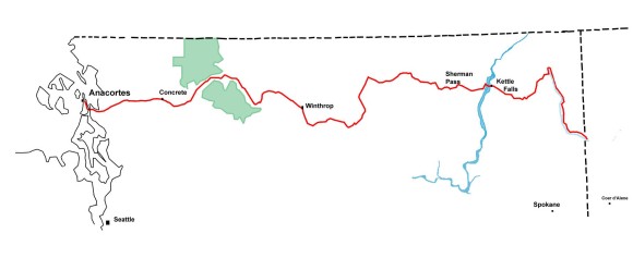
 Note: Click on the small photographs to make them bigger. Also, this blog series is available as a print-on-demand book. Thanks to Lloyd Peterson for the map.
This post is an overview of our trip through Washington State We went across the northern third of the state in eight days, much of the time on or near State Route 20. The route took us to the top of the Cascade Mountains on day 3, a climb of more than 3,000 feet. The fear of that day was a wonderful motivator for us to get out and train this summer. When it finally came, we were all surprised at how well we did.
We started at Bay View State Park near Anacortes, at the northeast corner of Puget Sound. The first day’s ride went through Burlington, Sedro-Woolley, Concrete, and to a campsite between Rockport and Marblemount. Most of our riding days were 60 to 70 miles, which allowed our older legs to rest every so often. We did 3,673 miles in 73 days, and 13 of them were rest days.
On day 2 we only rode about 30 miles, to the Colonial Creek Campground in North Cascades National Park. At the end of the day we were looking to the south at Snowfield Peak (8,347 ft) and wondering whether or not we were really up to this. But of course we were. On day 3 we continued past Diablo Dam and Ross Dam and up Granite Creek to Rainy Pass (4,855 ft), the Pacific Crest Trail, Washington Pass (5,477), and then a long downhill through the Okanogan National Forest, with Mount Logan (9,000 ft) and Gardner Mountain (8,900) to the south, and Goat Peak (7,000) to the north. We stopped at the Goat Creek Market in the village of Mazana, and slept at the KOA in Winthrop.
On Day 4, we went through Twisp (wasn’t he the spaceman on that box of cereal in the 1970s?) and continued by climbing to Loup Loup Summit (4,020). Then we descended out of protected land and passed the towns of Okanogan and Omak, along the west edge of the Colville Indian Reservation, with the Okanogan River just to our east. We slept at Margie’s RV Park in Riverside.
On Day 5, we headed north past Tonasket and then east, up to Wauconda Pass (4,310) with Mt. Annie to the South. We were in the Okanogan National Forest again, but this time in the Kettle River Range. We stopped for the night at the county fairground in Republic. On Day 6 we continued climbing the Kettle River Mountains to Sherman Pass (5,577) and then went down along Sherman Creek to the Columbia River, where we slept on the shore of Franklin D. Roosevelt Lake, which was formed by the Grand Coulee Dam. The dam is almost 100 miles downriver from where we rode.
Day 7 began by turning east again and gong through Kettle Falls and Colville. We passed through Crystal Falls State Park, and then began following the Little Pend Oreille and Pend Oreille Rivers on a long, lonely ride. We turned north on US Route 31 at Tiger and slept at an RV Park in Ione. On Day 8 we went down the east bank of the Pend Oreille, through the Kaispel Indian Reservation, and into Newport-Old Town, where we crossed the Idaho border. We rode 27 more miles that day, to Round Lake State Park. When we crossed the state line we had traveled about 400 miles, and they might have been the hardest miles of the trip – in terms of topography and temperature, at least. It was HOT!
3 replies on “Through Washington, Aug. 12 to 20”
Do you have an inventory of all of the equipment, food, etc. you guys are brining along? I’d be curious to see the scale of this enterprise of yours.
LikeLike
Speaking of floods in the Grand Coulee area (day 5) … This is the area of what may be largest flood of all time, the Missoula Flood.
This flood resulted from a breach of an ice dam and the maximum flow was several times greater than the combined flow of all of the other rivers in the world.
Evidence you will see are very large canyons and large boulders in odd places.
Note, this isn’t a flood reported in newspapers, rather in journals of research geologists. You may see roadside signs describing particular features.
Don’t miss the chance to learn about this to give you something to think about besides the wind.
BTW, we in the water resources field would call the backwater from Grand Coulee dam an inundation rather than flooding. In the interest of full disclosure I must admit that the last fifteen years of my career were spent with the Bureau of Reclamation. Grand Coulee is a Reclamation project and in terms of amount of concrete, Reclamations largest dam.
LikeLike
I found your site on technorati and read a few of your other posts. Keep up the good work. I just added your RSS feed to my Google News Reader. Looking forward to reading more from you down the road!
LikeLike