Categories
Rowing the Grand Canyon

Day Sixteen, RM 221-225: Scorpion, Derigging, Takeaways

D15BarkScorpionSafety experts say that every big accident is bracketed by lots of near-misses. You stomp on the brakes, your pulse spikes, and everything seems to slow down as you prepare for impact. The adrenaline in your bloodstream leaves a strange metallic aftertaste. You realize how quickly everything could change, and that your perch on the planet is really quite fragile. Then it wears off.

D16PedrpoUpstreamWe pulled in around 5pm on Day 15 to make the last camp of the trip.   It was still unreasonably hot, so everyone but the cooks headed for the river after hauling the gear onto the beach. Tania took her bathing suit out of her dry bag and when she slipped it on, she felt a sharp pain on her thigh. She swatted the spot, felt a second pain, and then saw something translucent and brown fall onto the sand.

Another thing safety experts say is that when something ominous happens, the most important thing is not to panic. So she didn’t: she called me over and said, with excessive calm, “I think I’ve been bitten by a scorpion.” I took a look at the critter, trapped it with a plastic cup, and called for the medic. Christie checked her book and confirmed that it was an Arizona Bark Scorpion, the dangerous kind, and that it had stung Tania twice. Then everything slowed down.

There wasn’t much to do except watch. The sting of a bark scorpion is a neurotoxin that causes pain, numbness and swelling which is worst at the puncture, but which can also escalate into whole-body symptoms like tingling, blurred vision, muscle twitching, drooling, sweating, vomiting, and dramatic swings in blood pressure and heart rate. We would know how bad it would be in a few minutes.

We were only five miles from a road, and there was only a small chance that this would become a life-threatening situation. Rod, Peter, Christie and I decided that if Tania’s symptoms escalated, someone would row her down to Diamond Creek—a trip that would take about an hour and 15 minutes—while Peter called for an ambulance on the satellite phone. The EMTs would arrive with the antivenom about the same time we pulled in. That was the best we could do.

Everyone else got back to making dinner. Christie, Tania and I went to the river; Christie applied a suction cup to the punctures and told Tania to soak her ass in cold water. Evening was coming on. Tania and I couldn’t find much to talk about, so we watched the afternoon light play on the rocks one last time. We stayed close to each other, and we waited. After twenty minutes or so, Tania said that the feeling on her thigh was like a wasp sting. She also felt tingling in her lips, toes, scalp, and fingertips, which was annoying but not disorienting. She was fortunate that the creature had been wrapped up in her bathing suit for a couple of days. He was probably weak and dizzy, and he didn’t get a good shot at her before she brushed him off.

We ate with the group and went to bed as soon as we could, skipping the final celebration. They were within striking distance of finishing all the beer, and several crew members were determined to achieve that goal. We drifted off listening to their happy voices. As the night crept along, I would wake up every hour or so to check on Tania; she was sleeping more or less normally, and each time I saw her regular breathing and touched her cool forehead, I felt relief and gratitude. The stars were so brilliant and the sky was so deep. I didn’t know when I would see a sky like that again.

We had spent more than two weeks in an environment that was incredibly beautiful but also incredibly hostile and many hours away from a hospital. We were in dangerous spots several times a day, and were constantly on guard against a long list of perils, from heat stroke to medical-grade sunburn, snakes, falls, a virus that would give you several days of violent diarrhea and vomiting, drowning, and of course, scorpions. Tania’s sting was the closest our group came to calling for a helicopter, but we had taken thousands of chances. I felt awe and gratitude for everything I had seen, but I also had an undeniable eagerness to get back to a place where mayhem didn’t seem so close.

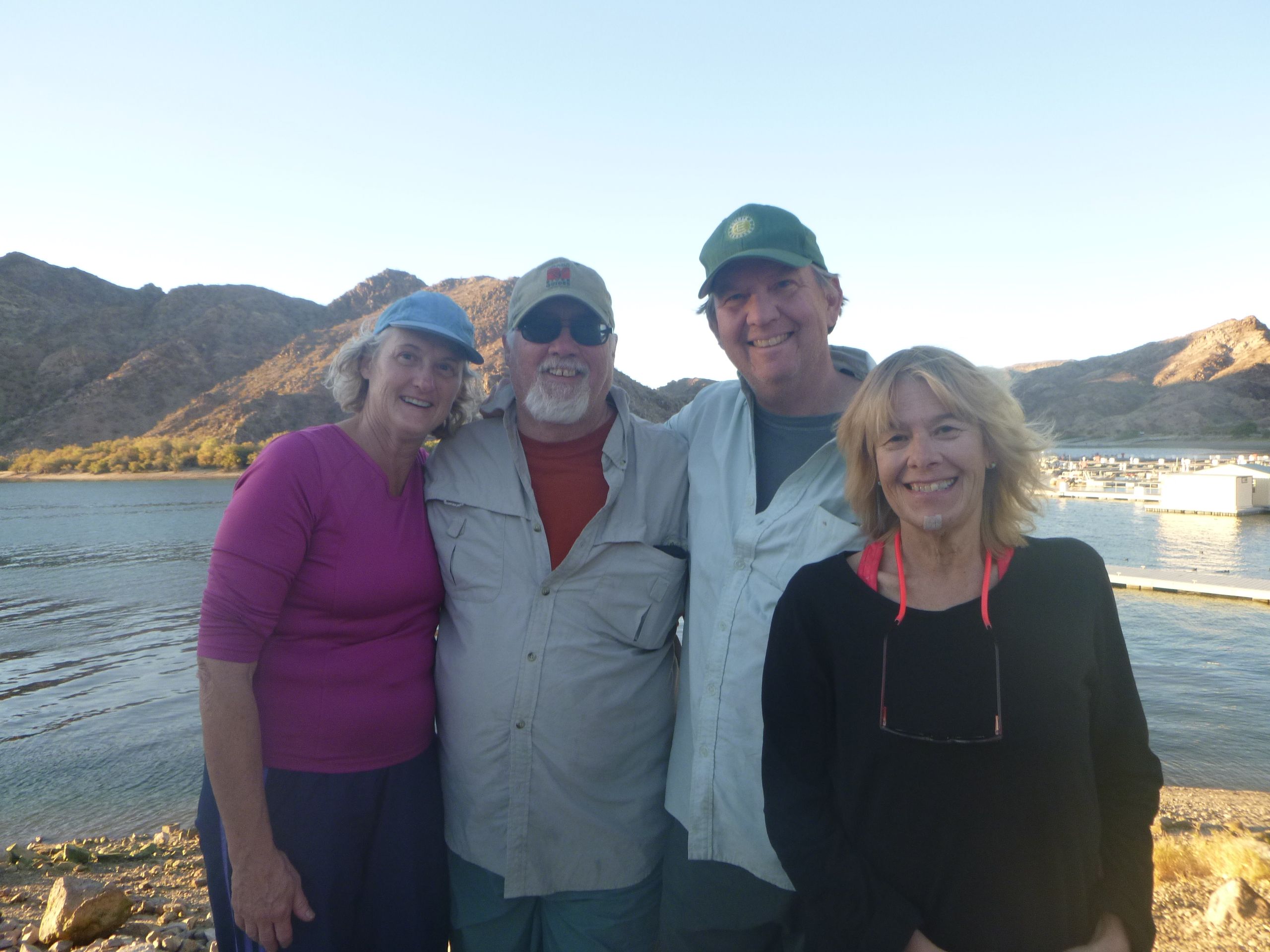
The truck and van that would take us back to Flagstaff was scheduled to arrive at 11am. Unlike Tim, Pedro, and several others, I did not battle a hangover. Tania woke up basically OK, although her tingling sensations remained uncomfortable for almost a week. Still, we D16BaerBreakfastcooked and ate our last meal together, washed, and packed efficiently, then paused for the day’s instructions before pushing off. Peter started by thanking Tania for surviving, and then he thanked all of us for making the trip so successful, enormously so, he said, and then he started to choke up, so we cut him off by giving him three cheers, like the experienced expedition team we had become. Then we were off to enjoy our last hour on the river.

Leading the trip was a stretch for Peter. He has superior wilderness skills, but he is also an introverted, detail-oriented person, and it wasn’t easy for him to let things go. I OLYMPUS DIGITAL CAMERAthink he saw all the risks we were taking, and those worries weighed on him. He was fortunate to have five other experienced boatmen, but managing them was another burden: they all had their own opinions about how things should run, and this was especially true of Jim. The friction between Peter and his older brother was difficult to watch at times, and I can only imagine how it must have felt for them.

Despite everything, Peter did a fabulous job of planning the trip, with a lot of help from Christie. And every day, on the river, Peter kept things from veering off course in dozens of ways that most of us never noticed, and Christie did the same for Peter. They were both completely unselfish about it. They picked the group, and they were also the biggest reason why we worked together so well.

D16HummingbirdNestWe stopped for a short hike on river left, where a few rock paintings waited patiently under a rock overhang. We walked up the side trail in a line, past shiny black schist, and I paused to notice my new friends: their patina of suntans and grime, the interesting patterns of male facial hair, and the many stains and rips on their clothes, each one carrying its own story. Next to a drawing of a stick man, a hummingbird had built a small, perfect nest in a tangle of vines.

100_5711Soon after we pushed off, Diamond Peak floated into view, and soon after that we pulled into the mouth of Diamond Creek. Tania was doing fine, but she was not up to the hot, hard job that faced us. I insisted that she stay in the shade with our few remaining morsels of perishable food, and I gave her the camera. She took pictures while we tore everything apart.

Like so much of the trip, de-rigging wasn’t easy. We emptied D16TimPoop
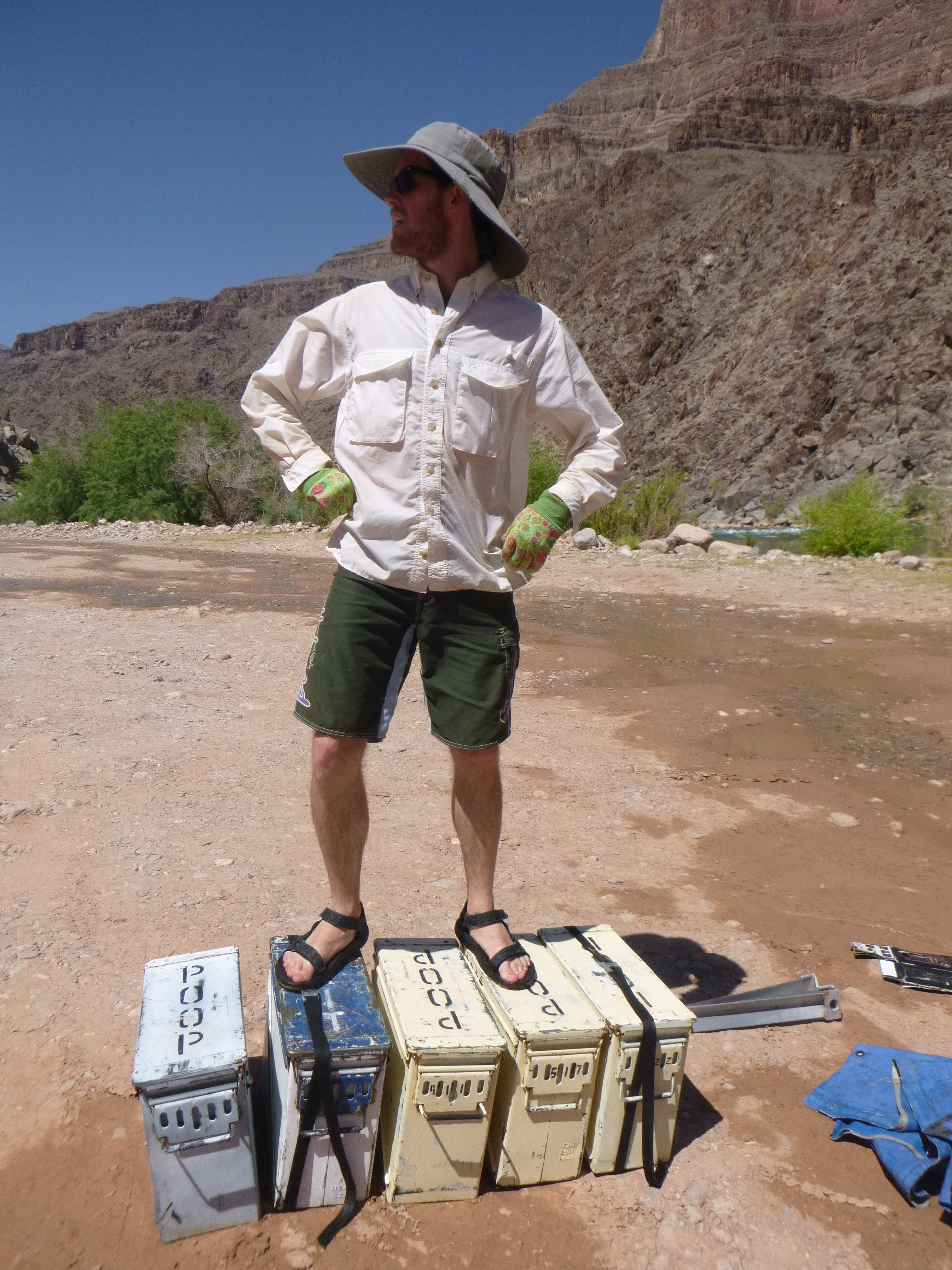
the rafts, including five ammo boxes, each packed with 50 pounds of our shit; five enormous Yeti coolers, some of which still had ice enough to keep cheese, meat, and a few soggy vegetables cold; the heavy steel frames that kept the rafts rigid; the kitchen; a dozen 12-foot oars, plus two spares; all our personal gear; and the rafts themselves, which had to be deflated, which involved lying on top of each section to force the air out, then rolling the vinyl up,

a three-D16LoadOutperson job.

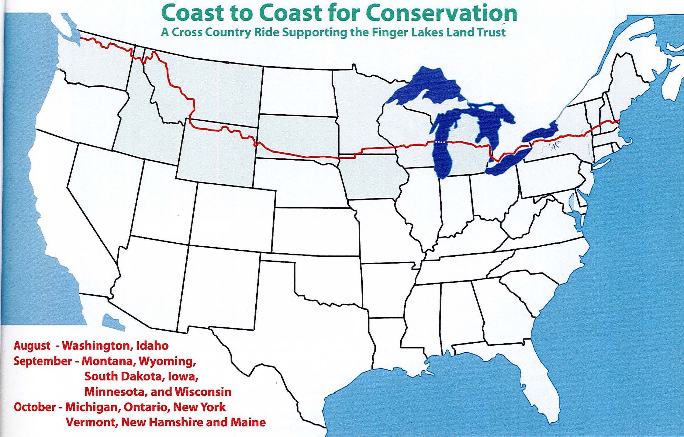
I have always enjoyed demolition. It was interesting to destroy the world we had depended on and throw it all into the back of a truck. But in the heat, there was no way to keep going unless you paused every few minutes to wade into the river. Once near the end, I looked downstream. We were skipping Travertine Canyon (RM 229), the site of yet D16RollingUpRaftsanother memorable waterfall; 232-mile Rapid, which has a feature the book calls “Killer Fang Falls;” Bridge Canyon (235), the site of the Grand Canyon Skywalk, a tourist attraction on the rim that locals refer to as “the toilet seat;” and Separation Canyon (240), where three members of John Wesley Powell’s crew abandoned their boats in 1869. They were never seen again. And just two days after they bailed, Powell’s expedition completed its 99-day journey. Today, Separation Canyon is a few miles above the beginning of Lake Mead.

I’m writing this several months after the end of the trip. Shortly after we got home, Tania finally decided to retire. She says that the river permanently changed the way she looks at life.

D16MotelShowerI’m a self-employed writer, so retirement is a meaningless concept to me. But the trip also reminded me of several important things. First, there’s no substitute for uninterrupted, face-to-face conversation. Over two weeks, I spent upwards of twelve hours a day having direct interactions with 15 people, ten of whom had been total strangers. Tania and I did not know when we would see them again after we went our separate ways. But the canyon had been a crucible for us, and I knew these friendships would last.

It’s ironic to be saying this in a blog, but the most valuable thing I remembered was the value of getting radically, completely unplugged and staying that way. Smartphones and computers are only one part of the problem. Electricity is what really needs to go. It takes several days to retreat deeply into nature, and the rhythms and silences you find there are far more satisfying than anything you might find on a screen. The pictures are better, too.

Quotes of the day:

Tim: “This morning when I threw up into the river, I forgot the strainer.”

 Jia: “A girl can only eat so much salami.”

 Rod: “Christ died for my sins. If he went to all that trouble, it would be impolite of me not to sin.”

Postscript: I asked my companions to write down their favorite memory of the trip, and got these three replies:

Christie Kroll: “The best moment was the part between Lee’s Ferry and Diamond Creek. But there were two honorable mention moments.

“Second runner-up: at the motel the night before we left for Lee’s Ferry, when dinner plans fell through, everyone jumped in to order pizza. It gave me faith that we had the right people for the trip. If you pick good people, the rest will take care of itself.

“First runner-up: On the little shade beach on day 15, we were waiting out the sun before making camp. Our campsite was only about 100 yards away, but we hadn’t claimed it. Peter looked up and said, “ Here come the commercial rafts,” and everyone panicked before realizing he had played a practical joke. It was hilarious and so out of character for Peter, whom I have lived with for thirty years. You think you know someone…

“And the winner is: river mile 109.5, sitting in a sunny spot along Shinumo Creek.

100_5152 copy
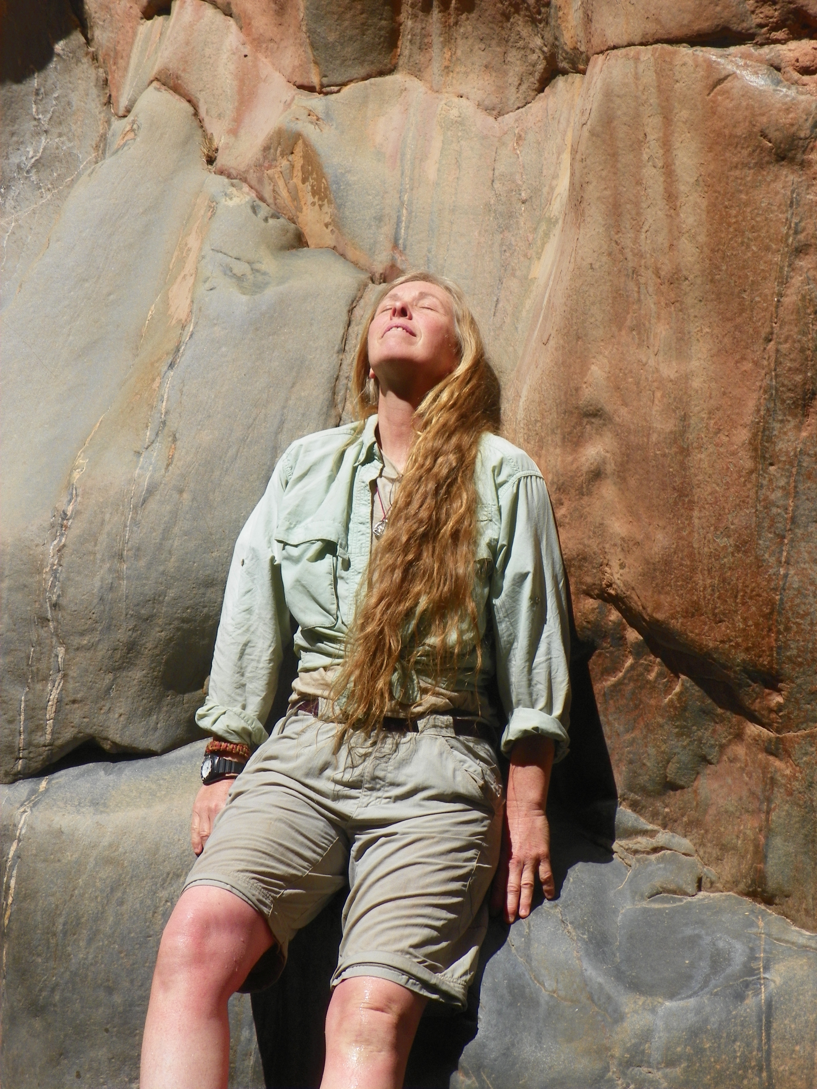
There’s a picture. We were halfway through the canyon. I had quit thinking about home, I wasn’t thinking about going back. Whatever concerns I had about putting the trip together were gone. Leaning back against the rock in the sun, I was clean and feeling chilled from swimming, the warmth of the sun, sublime. The patter of the waterfall echoed off the walls, punctuated with bits of happy voices.

Life felt so peaceful and so perfect. In that moment everything fell away, or I let it go. Color, sound, sensation, feeling, emotion. It felt very close to enlightenment.”

D16JaiPoopJia Carroll: “With the snow falling outside my window and the full return to ‘normal’ life, I just want to say ALL of it was memorable. But here is a more specific memory. By day 8, Gary and I had by this point become the dearest of river companions. We were an unorthodox duo, but a joyful pairing regardless. Gary had navigated the swimming rapid (Grapevine) and the flipper (Horn) with confidence and a read-and-run smile. For the first time in the trip, however, he seemed tense.

“We were heading for Crystal Rapid, the last big one of the day. The last time Gary had been on the river, he had gotten stuck in the rock garden at the bottom of Crystal. He was alone and his fellow boats left him behind, so his only option was risky: he had to get out of the boat and push it off the rock. He succeeded, but for a man who doesn’t like swimming very much, it was an unpleasant memory.

“I told Gary that I had total confidence in him. After all, I have seen him maneuver through tight groves of trees while schussing down a mountain on skis. I had seen him fishtail his way out of a rapid before, too. But the best part of the river is that it doesn’t give you a choice — you have to run all the rapids. So I tied down the water bottles, lashed every loose item to the boat, and held on for adventure.

“It ended up that Crystal was a breeze — Gary ran it perfectly. But what makes this one of my favorite memories is turning around near the end of the rapid and seeing Gary, his wild hair blowing in the wind, oars perfectly positioned, with the BIGGEST GaryPaintergrin on his face. He had conquered his fear and here he was, reveling in the joy of sweet success. All I could do was celebrate with him (and snap a quick picture, which you can see here).

“So what did I learn? That you might have more than one chance at a rapid; that you should face your fears; and that you only have one chance at it today, so why not grab the oars and smile the whole way through? There’s always a chance that you will end right side up in the pool at the bottom, more joyful than you ever thought possible. It was Gary’s overwhelming exhilaration and glee that I remember most.”

P1020554Tracey Metcalf: “So many ways to answer, so many moments. Was it when I realized I had left my new water shoes at Coal Creek (I’m still kicking myself over that), or when I saved the Monarch butterfly and watched it fly away? Or when I topped Little Bastard rapid in my inflatable kayak and saw that there was nowhere to go? I still wonder how Jim made it through.

“Don’t fool yourself into thinking that you will ever get the canyon out of your system. You have to settle for dreaming and scheming and asking yourself ‘when can I go back?’”

Categories
Bicycling Across The USA Travel Writing

Introduction

C2C4CUSMapWe dipped our tires into Puget Sound on August 12, 2008, and into the Atlantic Ocean on October 22.  The 3,700 miles in between are what this blog is about.

I rode across the country with Jim Kersting. Jim’s wife, Sara, drove their camper and was an essential member of the team.  We rode to raise money for the Finger Lakes Land Trust, an organization on whose board we had served, and in the end we raised over $30,000.  The 300 or so people who pledged support for our ride wanted to know what we were up to, so every evening when there was wi-fi, Jim and Sara set up a camp chair, put a cold beer in my hand, and told me to write a letter to the folks while they fixed dinner.  It was a once-in-a-lifetime writing fellowship.  It was multiple dreams come true.  I rode with a notebook and a camera and I kept my eyes wide open. This blog tells what I saw.

Note:  Click on the small photographs to make them bigger.  Also, this blog posts that follow are available as a print-on-demand book.

Introduction

I joined the Finger Lakes Land Trust in 1994 and met Jim and Sara Kersting there in 1996. Jim and I got to know each other over the next decade as we took turns being President. The Land Trust was growing rapidly, and some of the things Jim and I puzzled through on the board of directors were kind of sticky, but we persevered. Both of us love wide-open natural landscapes, dislike suburban sprawl, and think big. And Jim is a good leader. He knows how to use humor, mediate conflicts, set goals, and pursue them doggedly. We didn’t socialize much, but we liked each other. In the fall of 2006, when Jim asked me if I would be interested in joining him on a cross-country bicycle trip, it was easy to say yes.

Riding a bicycle across the country is something I had wanted to do since I was a teenager on Florida’s west coast in the early 1970s. In those days, a short ride could still get you out into big open landscapes, and at bicycle speed you could see things and hear yourself think. You could look for gopher tortoises on the roadside, watch ospreys and vultures wheeling overhead, and be alone with your tortured teenage thoughts. Bicycling endured as my favorite way to exercise, watch nature, and meditate. I never tired of it. The more cycling I do, the happier I am.

102208bradleyWilliam Blake’s Proverbs of Hell includes this one: “you never know what is enough unless you know what is more than enough.” When Jim asked, the time was right for me to finally find out how much bicycling was enough. My youngest child had just gone off to college. I had been self-employed for eight years, and was successful enough at it that I could afford to take a long break if I planned it well in advance. I was approaching age 50. I told Jim I needed a year to prepare, mostly for work reasons. He stuck with me, and he convinced Sara to drive their camper for support. Touring cyclists call this a “sag wagon,” and it is an endless source of tender mercies. Every day, Sara freed us from cold dinners, wet sleeping bags, and stinky clothes.

Sara and Jim are both retired and had their own reasons for making the trip, but I think we were all attracted by the audacity of three middle-aged people with middling physical abilities taking on such a task. We also knew that signing up for ten weeks of intense teamwork as a trio was risky, but individually we decided that it was a risk worth taking.

My wife Tania has a generous nature, and she also loves bicycling. She consented, and later she became an enthusiastic support driver and part-time rider. Bill Yust, an old friend of Jim’s, made plans to ride with us in August. Sara’s sister Catherine made her own plans to ride along in her car, also in August. The clock kept ticking. I kept telling people I was going to do it. After a while, I had told enough people that I had also convinced myself.

On August 10, 2008, I spent the day looking out the window of a westbound cross-country flight headed for Seattle. The plan was to meander back east through the same terrain, but on the ground this time, and much more slowly. It occurred to me on the plane that I had done something similar to the bike ride a year earlier, when I hiked 82 miles of the Finger Lakes Trail in six days. I walked through some of the most beautiful land in Central New York, where I’ve lived most of my life, beginning just east of Watkins Glen and finishing near Cortland.

I had visited most of the Finger Lakes’ “emerald necklace” of public forests and parks before the hike, but always in a car that whisked me from my house to the chosen pleasuring ground for a few hours and then took me back again. At highway speed, with the windows up and the radio on, you can get a glimpse of a bird or a ditch full of tiger lilies, but only for a second before you have to get your eyes back on the road. When you’re walking, you can count the lilies in a marsh and also see sunlight reflecting off the water. You can call to a bird in its own language and if you’re lucky, it will answer.

Central New York unrolled before me on that hike like a long story told at leisure, with lots of time to think about what I had seen. I learned how to tell the difference between a farm field that has been reclaimed by trees and a second-growth forest that has never been anything other than a forest (look at the ground; if it’s smooth, it used to be a field). I understood glacial topography a lot better once I felt the hills in my legs. I lost a few pounds and got stronger. And although it was uncomfortable at times, I finished the hike thinking how grand it would be to do this for a much longer stretch of terrain. I wanted to climb the Rocky Mountains instead of Connecticut Hill. I wanted to sleep outdoors for weeks at a time, with the company of friends in the evenings instead of a media cacophony. I wanted to transect North America at 10 miles an hour and learn as much as possible from the sample. And I wanted to write about what I had seen without any instructions from an editor.

Somewhere in the months leading up to it, I turned the ride into a self-improvement exercise, with a hope that it would help me shake some bad habits. One of these is procrastination. If no one is paying me to write something, I tend to put it off. Over the last 35 years, this has lead to several boxes’ worth of projects that are unfinished because I have always put other things ahead of them: volunteering for worthy causes like the Land Trust, cleaning the house, cooking, enjoying myself, and living well in other ways while the sand runs through the glass. Procrastination is like a compulsion because it drains the pleasure from these good things. I know that I should pay attention to writing ideas when they come knocking, but I had not been able to keep myself from dithering.

The real pros do not have this problem. In his memoir On Writing, Steven King advises aspiring writers, above all, to have discipline. Never leave your desk for the day, he says, until you have written something – 500 words, or at least a single paragraph — that you know is worth keeping. One of the reasons this self-evident rule works is because it redefines the task. It isn’t a big, scary book any more. Today, it’s just 500 words. The rule worked for the bike ride, too. I realized that I could ride across the U.S. when I stopped thinking of it as an enormous 3,600-mile ride across an entire continent and started thinking of it as 60 rides that are each 60 miles in length, with rest days scattered among them. I knew I could do that. And if a 100,000-word book is really seven or eight months of meeting a 500-word daily quota, maybe I could do that too.

Jim wanted to ask our friends to make donations toward the ride that would support the Land Trust’s stewardship fund. This turned out to be wildly successful, and by the time we finished we had collected $39,000 from nearly 200 people. I came up with the idea of making blog posts from the road so that the people who had supported us could ride along. Knowing that I had this audience gave me the energy to take notes during rest breaks, snap photos with my trusty old Canon PowerShot, and stay up after dinner to type it into my MacBook Pro. It also cleaned some rust out of the writing pipes. It helped that I saw much more amazing stuff in a typical day than I could ever put into words.

The little things you see on a bike ride can be like the first sentences of short stories. On the first day of the ride I flashed past a girl with a weed-whacker who was trimming around the bases of some wooden crosses that had been set up beside the road. They didn’t look like a cemetery, or even like one of those roadside memorials to a fatal car crash, although they might have been either. They looked like a display of faith that was on exhibit but was also private. I spent the rest of the ride imagining what the girl was thinking as she trimmed the grass.

In Michigan, I saw an empty box of Little Debbie Swiss Rolls on the side of a rural highway. Immediately I imagined that a woman had thrown the empty box there because her boss had yelled at her during her shift at the dollar store. The woman had been pretty and popular in high school, but now she had two small kids and her husband worked the night shift. She stole the box from work and ate the whole thing on her way home because she needed to get something into her that felt something like affection. Then she threw the box out the window so her family wouldn’t find out about her secret bad habit.

Writing well requires long stretches of solitude. I’ve been making a living as a writer since 1981, so I know how to grind out magazine prose and meet deadlines. But there’s not much of a spark in that kind of writing, no wild rush as you realize that your pen is scratching out something unexpected, no sense of wonder as you make a compelling image or phrase and you’re not sure where it came from. To get on top of that game, you have to practice alone. That’s what the ride was: hours of rumination in the saddle, followed by an afternoon or evening spent pouring out the results at some picnic table.

After I left Florida at age 17, I lived on a ranch in eastern California for three years. Back then, I thought solitude alone could produce great writing. I had the luxury of self-absorption, a privilege granted only to the immature. I would wander through the desert for days at a stretch, reveling in the beauty of what I thought at the time was untouched wilderness, as infatuated with myself as Walt Whitman ever was, communing with truth and beauty and completely unconcerned that on the other side of the country. I had a mother, grandmother, and other people who were worried about my safety and longed, mostly in vain, for some news about how I was doing. I had a great time, even if I can see now that I was acting like a complete jerk.

The big bike ride was not like that. The act of saying goodbye to my family and friends made it clear to me that there were a lot of people who were deeply concerned about my safety and welfare. On the plane, I thought of each of the people who expressed their concern for me in ways that were unique to them, and which also encapsulated the value of all the years we had known each other. For some it was a hug; for others it was a stern warning to get a complete physical. I could see the love in each of those gestures, and I will always remember them. As the ride wore on, I keenly missed my friends and the home Tania and I have made. Somewhere on the way to middle age I had become a homebody and a family man while remaining a writer.

My life so far has been a story of incredible luck and undeserved privilege, as well as the usual boring stuff about hard work. My wife is smart, funny, pretty, and kind; my kids are loving and talented; I have dozens of loyal friends who lead interesting lives and can also tell good jokes; I have more than enough stuff. But looking back, I can also see several important moments when I passed on the chance to do something important because something bad might happen if I tried. Timidity and negative thinking and their father, fear and laziness, have dogged me since childhood. One reason I did the ride was to conquer these things.

When I told people my plans, some of them were envious and expressed admiration. Others looked at me funny. Some of the skeptics even said what I believe all of them were thinking. Why spend months away from your job, burning through money instead of making it, when you’re supposed to be in the prime of your career? Why do a dangerous thing that worries the people who love you. if you don’t have to do it? Why do something that you know will hurt – maybe a lot – and will probably be, at times, truly unpleasant?

One of the people I told about the ride turned away and wouldn’t talk about it. Another asked me if there was any way she could talk me out of it. I grilled myself, too, imagining broken bones, chipped teeth, stolen property, drunken drivers, and as one good friend memorably put it, “getting smooshed.” But then I went ahead and did it anyway.

A writer has to be selfish sometimes to do the job well, because a writer has to find an authentic voice. Retreating into solitude is essential for writers because it is the only way to nurture that voice. Thousands of people make long-distance bicycle rides every year, and hundreds of them keep blogs. Most of those blogs are not interesting to non-riders because they describe the internal facts of the ride: gear, nutrition, routes, weather.  I didn’t care very much about these things.  I was a hunter-gatherer going out every morning in search of material, and I found much more than I managed to capture in writing.  It is all stored somewhere in memory now, waiting to be recycled in ways I can’t forsee.

I went with Jim and Sara to grant myself time to see, listen, and speak freely. What follows is what came out.

Categories
1. Washington Bicycling Across The USA

Through Washington, Aug. 12 to 20

c2c_washingtonmapNote:  Click on the small photographs to make them bigger.  Also, this blog series is available as a print-on-demand book.  Thanks to Lloyd Peterson for the map.

This post is an overview of our trip through Washington State We went across the northern third of the state in eight days, much of the time on or near State Route 20. The route took us to the top of the Cascade Mountains on day 3, a climb of more than 3,000 feet. The fear of that day was a wonderful motivator for us to get out and train this summer. When it finally came, we were all surprised at how well we did.

We started at Bay View State Park near Anacortes, at the northeast corner of Puget Sound. The first day’s ride went through Burlington, Sedro-Woolley, Concrete, and to a campsite between Rockport and Marblemount. Most of our riding days were 60 to 70 miles, which allowed our older legs to rest every so often. We did 3,673 miles in 73 days, and 13 of them were rest days.

On day 2 we only rode about 30 miles, to the Colonial Creek Campground in North Cascades National Park. At the end of the day we were looking to the south at Snowfield Peak (8,347 ft) and wondering whether or not we were really up to this. But of course we were. On day 3 we continued past Diablo Dam and Ross Dam and up Granite Creek to Rainy Pass (4,855 ft), the Pacific Crest Trail, Washington Pass (5,477), and then a long downhill through the Okanogan National Forest, with Mount Logan (9,000 ft) and Gardner Mountain (8,900) to the south, and Goat Peak (7,000) to the north. We stopped at the Goat Creek Market in the village of Mazana, and slept at the KOA in Winthrop.

On Day 4, we went through Twisp (wasn’t he the spaceman on that box of cereal in the 1970s?) and continued by climbing to Loup Loup Summit (4,020). Then we descended out of protected land and passed the towns of Okanogan and Omak, along the west edge of the Colville Indian Reservation, with the Okanogan River just to our east. We slept at Margie’s RV Park in Riverside.

On Day 5, we headed north past Tonasket and then east, up to Wauconda Pass (4,310) with Mt. Annie to the South. We were in the Okanogan National Forest again, but this time in the Kettle River Range. We stopped for the night at the county fairground in Republic. On Day 6 we continued climbing the Kettle River Mountains to Sherman Pass (5,577) and then went down along Sherman Creek to the Columbia River, where we slept on the shore of Franklin D. Roosevelt Lake, which was formed by the Grand Coulee Dam. The dam is almost 100 miles downriver from where we rode.

Day 7 began by turning east again and gong through Kettle Falls and Colville. We passed through Crystal Falls State Park, and then began following the Little Pend Oreille and Pend Oreille Rivers on a long, lonely ride. We turned north on US Route 31 at Tiger and slept at an RV Park in Ione. On Day 8 we went down the east bank of the Pend Oreille, through the Kaispel Indian Reservation, and into Newport-Old Town, where we crossed the Idaho border. We rode 27 more miles that day, to Round Lake State Park. When we crossed the state line we had traveled about 400 miles, and they might have been the hardest miles of the trip – in terms of topography and temperature, at least. It was HOT!

Categories
1. Washington Bicycling Across The USA Jim's posts

Jim on Day 1

We did have our first adversity test mid-day on Day 1 when Brad’s tire was going flat and doing a “whopity-whopity” thing. Three tubes later we were back on the road. Why three tubes? Don’t ask.
Rockport State Park closed the campground for fear that their old-growth cedars and redwoods would smoosh the campers. We rode through the old campsites (after ignoring the barriers) and wondered what all the infrastructure would look like in 20 years with all the moss encasing the buildings, etc. The detour came near the end of the day when the saddle was seeming especially tiny and protruding, but the stop was worth every bit of discomfort.
We road along the Skagit River for most of the day on the other side of the river on a quiet road, but with a clear view of either a mud slide or a logging operation. 
Categories
1. Washington Bicycling Across The USA

Day 1: Up the Skagit River

The Clark Family Cabins are a great place to camp, with a family of pet bunnies and cabins across the way that are outlined in white Christmas lights. Jim and Sarah realized with a shock that they stayed here 15 years ago shortly after they pulled in.

Day 1 of the ride took us from Bay View State Park, on the east shore of Puget Sound, through the delta of the Skagit River and then along its banks to the foothills of the Cascade Mountains. Before we rode, we met Martha Bray, Conservation Director at the Skagit Land Trust, near one of their projects on Fidalgo Bay. I made a video of Martha describing some of the group’s work, which is available online at http://www.c2c4conservation.org. Then we made a second video on the mud flat near the State Park (it was low tide). We dipped our tires in the Pacific (in spirit at least), and then we were off.

We rode east along farm roads through rich agricultural land. The father of all that soil, Mount Baker, loomed at 10,000 feet in the eastern distance. After about seven miles we passed over Interstate Five, and then went along more farm roads. The scenery changed ; suddenly there were tall hills to the north and south of us. It was about 70 degrees and sunny and so beautiful that (l-r) Bill, Jim, and I took turns making whoops and exclamations and all those things you do when you can’t put something wonderful into words. Jim and I have been tallking about making this ride for two years, and all day I was having trouble processing the fact that it is finally underway.

We took a break at a simple little park in Sedro-Wooley, an ag town, with a small group of mommies and kids and dogs standing at attention near the monkey bars. Then I had a flat tire. It took a while to fix – it wasn’t a simple problem – but we did fix it, and the reward was a 30-mile cruise along the south bank of the Skagit River. What a road.

The Skagit is greenish and fast-flowing and so cold that your feet hurt just a few seconds after you put them in it. It is largely glacial meltwater from Mount Baker, which happens to be an active volcano. Loren Ihle, an old friend I visited the day before, told me that every few hundred years Baker lets off a huge jet of super-heated gas that flash-melts a great deal of the glacier. The water courses downhill and picks up mud and rocks and boulders and becomes what is called a “lahar,” a wall of mud several dozen feet high moving about 60 miles an hour. That’s where all the great soil comes from. Oh course, a lot of people have moved into the area since the last lahar, but that’s life in the American West.

We rode for several hours along the Skagit, watching as the hills closed in on ether side and got taller, and every so often there would be a glimpse of something craggy and snow-capped in the distance. We did not climb very much – that starts tomorrow, and on Thursday we will climb about 4,000 feet. I think the best words to describe our attitude toward Thursday are “confident, yet respectful.”

At the town of Concrete (hometown of author Tobias Wolff and the setting of his great memoir, This Boy’s Life) we met Washington State Route 20, also known as the Northern Cascades Scenic Highway, which will be our route for the next 400 miles, give or take a few. Concrete is a worn-out looking place; the concrete plant has closed. We got laughed at by a drunk couple sitting in front of a bar called “The Hub” that was blaring Lynyrd Skynrd at 4pm on a Tuesday afternoon. Fair enough.

In a flash we were back into the feast of scenery and, 15 miles later, the day was over. Tomorrow we start the Cascades in earnest. -Brad

Categories
1. Washington Bicycling Across The USA

Days 2 & 3: Across the Cascades

7am Aug. 13: Kenny Cuthbert

Day 2 began at Clark’s Family Cabins on Washington State Route 20, just west of Marblemount. Until 1972 the highway ended here and this stretch of the Cascades was fairly roadless; in 1972, the North Cascades Scenic Highway was completed amid much fanfare. Concrete still celebrates “Cascade Days,” a festival thought up to promote the road, even thought the road skipped the downtown. I woke up at first light. I wandered over to Tootsie’s, the restaurant attached to the cabins, and found it booming. Sitting alone at a two-seater was an old man with Native American eyes and a U.S. Navy baseball cap. We got into an easy conversation while I waited for a take-out order of sticky buns, the local specialty.

Kenny Cuthbert had an oversized coffee mug that was obviously all his. He had the look of someone who comes into Tootsie’s every morning and orders the same thing. His grandfather came into this country from Scotland, he says. I’m guessing his grandmother was the Indian. Before the highway went through, there was a dirt road up to the power plant that turned into goop whenever it rained; there was also a rail line to the plant, which is how everybody got there. Above the plant there were trails blazed by Indians and trappers and not much else. “There were people in this valley who never learned to drive,” he said. “I knew a fellow who lived in a cabin up the hill, and he’d walk into Marblemount every so often with a sack lashed to his back to get supplies, and that was it. He didn’t see the point of a car.” Another guy Kenny remembers got so mad at his old Model A when it wouldn’t start that he beat it to pieces with a big stick, right in his front yard.

Kenny smiles when he hears that we’re planning to ride over Washington Pass tomorrow. “Careful on the way down,” he says. “Guys on bikes used to wear parachutes on the downgrade. If their brakes failed, they’d pop the chute and coast to a stop. It’s a big down.”

We could have talked all day, and eaten a lot of delicious food too, but the buns came and I had to get back to the crew. I said goodbye with regret to this ambassador from the days before low-fat yogurt sprinkled with high-fiber cereal. As I stood up, the waitress brought Kenny two biscuits covered with sausage gravy and a melon slice garnish. She refilled his coffee. “Bye now,” he said. “Hope you get there.”

7/13, 2pm: The Skagit Drowned

Day 2 was a short day – only 30 miles or so, and pretty flat. Our stops are limited to where the campgrounds are. We rode through Marblemount, which has been catering to tourists since 1885, and before long we got to the power plant. The Skagit is a big river. It rises in British Columbia and drains a huge watershed of wet country, so by the time it’s done it contributes 20 percent of all the fresh water entering Puget Sound. In 1918, the City of Seattle damned it for hydroelectricity. It provided more than 100 percent of the city’s electrical needs for many years; these days, it accounts for about 25 percent. That’s a lot of carbon credits. Unfortunately, it also makes two huge dead lakes in the middle of some of the most unbelievable mountain scenery in the lower 48, and it has walloped the native salmon population.. This “green living” stuff is awfully complicated.

There are many wild stories about the things people went through to dam the river, string the lines, and flip the switch. I bought a book, “North Cascades Highway” by Joann Roe, that promises lots of entertaining reading. We arrived at the Colonial Creek Campground, which was big and packed and not very nice, and had a swell meal cooked by Sara and her sister Catherine (Jim and Bill did the dishes). We were kind of anxious because the weather was getting hot, and we had to climb 4,500 feet over 33 miles in the morning and then do the big down and another 20 miles after that in the afternoon. We resolved to go to bed early, which we did, and then some jerk in the space next to us got out his guitar and started singing Eagles tunes. Wilderness it weren’t.

Day 3: Up and Down

We were rolling at 6:35 am. Progress was steady, traffic was light, and the Cascades were sublime. After we got above the drowned river, we got to ride next to a delightful wild stream, Granite Creek, as the road rose steadily before us. Those Western highway engineers were artists with dynamite. The pitch never got too steep, and we only stopped briefly every hour for more water and food. At 10 am, Catherine drove up with more water – I went through nine bottles by the end of the day. By noon we were at the top (Jim at Washington Pass, middle), and we made a short video in which Jim screams, “We feel GREAT!”

Then we started a seven-mile long 7% downgrade that was like a ski run from the top of Vail. It was just as thrilling and just as dangerous – you wanted to let it rip, but above 30 miles per hour you realize just how easy it would be to go over the side or how far you’d skid if you went down, so you hit the brakes.

We descended from 5400 feet at the top of the pass to an elevation of about 1,000 feet when the road finally leveled out. It got hotter as we continued down, until at the end it was truly furnace-like. I do mean exactly that. It felt as though you had your face next to the vent of a forced hot air furnace, and all that dry, hot air was blowing on you constantly. There were zero clouds. The hills were burnt brown, like Eastern California. We rode past large irrigated alfalfa fields, stopped at a charming grocery store for rich hippies in Mazama, and then panted our way down a beautiful stretch of asphalt called Goat Creek Road (below).

After 90 beautiful but extremely hot minutes, we pulled into our destination for the night, the town of Winthrop. It is both the regional center and a major sink for tourist dollars, and everyone on main street seems happy and well-fed. Earlier that day we had seen cops in soldier uniforms massing at the side of the road in a couple of places. Perhaps the military dump truck loaded with marijuana plants that we saw at the gas station that evening was their day’s work (below). Although the cop guarding the haul was very nice, he wouldn’t say.

Categories
1. Washington Bicycling Across The USA Land Stewards

Day 4: Loup Loup Pass, Margie’s RV Park

The heat has become our enemy. By noon it’s nearing 90, and by 2pm on the highway the temperature is well above 100. It doesn’t start cooling down until 6pm or so. “We go in and out of heat like this in August,” said a local man at a rest stop on Thursday afternoon. The Methow River was just below us, running cool and clear over large smooth stones, but a steep slope of nasty-looking brush separated us from the water. “It can go up above 100 for a few days like this,” he said. “Nobody goes out in it unless they have to.”

Unfortunately, we have to. The forecast is: hot on Friday, hotter than that on Saturday, and hotter than that on Sunday. Each day we have to climb 3,000 feet to a mountain pass. So what we do to make it work is get up before sunrise and do as much of the ride as possible before noon. If you’re on the road after 1pm, it isn’t fun any more; after 2pm, you get cranky; and after 3pm, things could easily go seriously wrong in several different ways. But we had a great time despite the heat. On Friday, Day 4, we started at 8am and ended at 2pm at one of the best campsites yet. It was another beautiful ride, although a different kind of landscape this time.

We woke up at the KOA in Winthrop and rode south down the Methow Valley in slanted early morning light. We startled the mule deer, ogled beautiful old ranch houses, watched a hot air balloon on a morning joyride, and clucked with disapproval whenever some software millionaire’s Sundance-style palace appeared. Before long we were in the town of Twisp, which wasn’t much, and I looked in vain for some indication of how they came up with that name.

Heading out, we were hailed by two of our new friends: Jason Paulsen, director of the Methow Conservancy (left), and board member Tom Doran. We chatted for a while and they told us about some really exciting stuff there were up to, including a $20 million capital campaign. We were reluctant to leave, but the sun was climbing.

We turned east and started up a truly deserted road, climbing toward Loup Loup Pass (“Loup Loup” is another word for a Pomeranian or Spitz dog, but I didn’t see any). Sage and rabbit brush lined the road at the base, along with a farm where fresh-cut alfalfa was drying in the field. Before long we passed the entrance sign to the Okanogan National Forest, pronounced with a long “O”. Trees started to appear: Ponderosa and Lodgepole pines, Cottonwood and Manzanita along the banks of a small creek we could hear but couldn’t see. We went up 2,300 feet over 12 miles and hit the top of the pass right at noon.

The downgrade from Loup Loup Pass was delightful. It was not as steep as the Big Down from the Cascades that Kenny Cuthbert had warned me about, so there was less white-knuckled braking and more cruising with the wind in your face. We went down and down some more until we had lost more elevation than we had gained. The trees thinned out and the sage came back, and before long there was hot air, and then hotter air, and then air much hotter than yesterday’s hottest air. None of the Forest Service campgrounds we had passed had water, and we were getting low when our saving graces, Sara and Catherine, passed us and pulled over and refilled everything. After thanking them profusely, we turned north again and started down into the Okanogan Valley, and then it got really hot.

The Okanogan Valley is prime fruit-growing country, thanks to the great big Okanogan River flowing through the middle of it. Nothing would grow without irrigation, but when you combine the water with the desert’s lack of bugs it produces delicious pears, plums, cherries, and lots of other fruit. It also produces apples that are not as good as New York’s, because they never go through a real cold snap. But since Washington apples are cheaper to produce and ship, they are often the ones you’ll find in New York supermarkets. So if you’re grocery shopping and it doesn’t say where the apples came from, always ask for the ones from New York.

If Winthrop was all make-believe Wild West for rich tourists, the connected towns of Okanogan and Omak were a harsher Western reality. Just east of these towns is the huge Colville Indian Reservation. We could see small houses out in the desert baking in the sun. It was the kind of road where you’d find a large kitchen garbage bag, full of food waste and other crap, casually tossed in the ditch. We rode past a plant that turned pine trees into pellet fuel for stoves; we saw tents out in the fruit fields, so the workers would have somewhere to get out of the sun; and it got hotter. The Okanogan River is a beautiful, deep channel lined with trees. It was a balm to our boiling eyeballs as we slowly pedaled down a long, straight road toward our goal. Fortunately the road was flat, and there was a tailwind. On one of the most desolate stretches I saw one of those roadside memorial crosses. It had plastic flowers at the base and the words “MARY, 1968-2002” burned into the unpainted wood.

We got to our destination – Riverside, pop. 300. We went into their one little store to drink the coldest thing they had. Sitting out front, we said hello to an elderly man with a cane, and then to his wife, who was wearing a pink t-shirt that said Wauconda Garden Club, blue jeans, and white deerskin gloves. “I’m on my way to the garlic festival in Tonasket,” she said. “The hippies grow it up there.” The club sold barbecue and last year they had raised $1,000, she explained. I asked whether it was a formal event, because of the gloves, and she laughed and said that she was wearing them because her steering wheel was too hot to hold onto. Across the street was a great-looking old-fashioned western store. I would have bought a straw cowboy hat if I could have carried it in my bike bag.

When humidity is low, the contrast between sun and shade is dramatic. Margie’s RV Park is a small mom-and-pop place near the highway with big green lawns and shade trees, and as the afternoon wore on it seemed like the best place in the world. Our campsite was under a Catalpa tree, a variety that Sara and Jim both had in their yards when they were growing up. We went down and jumped in the Okanogan and chatted with a young man who was with two little kids and a pretty girl. The girl was pregnant and smoking a cigarette. Then Jim and I got back in the truck and went to Wal-Mart in Omak to get energy bars. Sara and Catherine had done a big grocery shop earlier but had not found these, and Jim and I were surprised to find out how finicky we are in this category. HE likes Luna bars, even though the packaging says they’re made for women.  I like Clif bars because they remind me of the big messy cookies you used to get in hippie bakeries in the 1970s.

Back at the campsite, we had burgers and chocolate and quickly packed up and went to bed. The forecast for tomorrow is even hotter than today’s forecast was. As soon as the sun disappeared, it got pleasant; as the night deepened, it got cooler; and somewhere in the middle of the night, I pulled on my down sleeping bag.

Categories
1. Washington Bicycling Across The USA Jim's posts

Jim on Day 4

I woke up feeling slightly pummeled after three days of riding, and the open oven- door heat of Thursday afternoon. What will the next 3-4 days of 100º’s be like? A bit of bad luck to have caught a near record heat wave in this NE corner of Washington. We could drive out of this heat wave in a half-day. We will instead pedal through it over four.

The Methow Conservancy’s front door is bicycle length off Main St. in Winthrop Wa. I dropped in and had a conversation with the Director Jason Paulsen and Emily, who directs membership. Their focus is on the 1,000,000 acre Methow River Watershed, and a capital campaign of twenty times as many dollars. I was more than impressed. I was also more than just a little smelly, and it was very obvious who the elephant in the store was. A retreat to our camp at the local KOA was necessary.

Sara and her sister Catherine have been herding the gear, shopping, and cooking while we have been riding. The five of us are having some good times punctuated with laughter around the dinner table. But the effort to keep everyone fed and bedded is not slight. It has been full-time job with a few pauses to adsorb this scenery and culture. We took in both last night at a riverside outside deck at the Schoolhouse Brewery.

It is now 6AM, the boys are breaking down their tents and I need to serve coffee. The saddle awaits.

JK

Categories
1. Washington Bicycling Across The USA

Day 5: Wauconda Pass

“All night long I stand there and watch sheets of plywood go by. It is the most boring job I’ve ever had,” he said. I had just woken up. We were talking in the men’s washroom at Margie’s RV Park. He was in the shower. I never saw anything but the top of his head. “I had a welding job in Wenatchee and I thought I didn’t like that so I quit it, but I shouldn’t have,” he said. “Now I’m thinking about going down to the tri-cities, or maybe Eugene.”

“What will you do there?”

“I don’t know. Just get a job I guess.”

Why does the Western U.S. have the nation’s highest rates of suicide and divorce? You can glimpse the answer at Margie’s and other RV parks that have turned into semi-permanent lodging for low-paid workers. There are a lot of drifters in the West, and they aren’t nearly as sexy as Clint Eastwood. They are unloved and unfocused. Their lives are hard, and it’s easy for them to get liquor, drugs, and guns. We woke up at 4:30 am when a large truck parked next to a nearby trailer roared to life and its owner left for work. Several more residents had left by 6:45am, when we pulled out for the day’s ride. How fortunate I am to be doing this, I thought, instead of watching plywood all night.

We rode north up a slight incline in the Okanogan Valley called the Wagonroad Coulee. It was 15 miles to the town of Tonasket. Then we’d turn right and head east, into the Kettle River Range, with a 3,000-foot climb over 22 miles to Wauconda Pass. The trick was gong to be getting to the top before it got too hot, without pushing too hard. Then we’d lose 2,000 feet and end the ride in Republic, 60 miles further along.

We rode fast and easily on the coulee in the beautiful early light. The sun had just topped the large upthrust granite slabs at the eastern end of the valley. Dew was evaporating off the sagebrush, producing one of my all-time favorite smells, and every so often a meadowlark would cut loose from his perch on a fencepost. A “Coulee” is a small hill inside a valley, and every time we topped one of them we would see a new vista. My wife Tania, who is the best travel companion I’ve ever known, loves traveling through western scenery because, she says, each slowly revealed vista is like walking into a new room. I have already seen dozens of things I want to show her, and we haven’t even been riding for a week.

We hit Tonasket at 8:10 am and paused at a convenience store long enough to re-fuel ourselves, then headed up the pass. It was maybe 80 degrees. Bonaparte Creek was running just to the right of the road. It was small but noisy, and after a steep beginning things leveled out for a while. The western slope of the Kettle River Range is wide-open country and the trees don’t begin until around 3,000 feet. I saw lots of abandoned or questionable ranch buildings, their boards turning to fuzz in the heat. I saw a tin man and woman decorating someone’s gate. I remembered what some writer, maybe Nathaniel West or Raymond Carver, had said: that western hills covered with grass looked like the backside of a recumbent woman. Annie Mountain rose to the south. There are a lot of lonely guys in these parts, ma’am.

Two miles from the top, very hot and low on water, we reached the Wauconda Store and Café. If you look up the word “oasis” in the dictionary, there’s probably a picture of the Wauconda Store next to the definition. Although there wasn’t another building in sight, the store was obviously a community center. Wauconda started as a gold rush town in 1896 and proved enough ore to keep miners employed for several decades, by which time the ranchers had come in. “Yesterday we took in $1,100, which was fantastic,” said Brenda Wahner, who works at the café and lives alone in a trailer nearby while she’s building her house. “In the winter, the locals keep us going It’s cold here, but not like Duluth.”

Brenda and Jim talked about growing up in Minnesota. She poured me two huge glasses of iced tea and made Bill a grade-a chocolate milkshake. We signed the register they keep for cyclists, Several cross-country riders pass by every week during the season, and this summer the cyclists they had seen were raising money for cancer, animal rescue, and Jesus in addition to the Land Trust. Take your pick!

After struggling up the last two miles to Wauconda Pass, we had another flying descent through trees and back to the brown-grass hills, with the wind in out faces getting hotter as we continued down. At the end we were in Republic, the seat of Perry County, and we found another green shady spot in a public campground at the county fairgrounds. Republic is a big enough place to have a library with a wireless router, so we spent the afternoon online. After a shower and a fine steak dinner, dusk came and we went straight to bed. We’re facing another 3,000 foot climb tomorrow


Categories
1. Washington Bicycling Across The USA Jim's posts

Jim on Day 6

Over these past six days, I have had some thoughts bouncing around like the ball careening off posts and bumpers in a pinball machine. Perhaps I am living in a continuous state of heat exhaustion, and the pan-seared portions of the top of my head have become nothing but posts and bumpers.

The first two hours of our rides have been glorious; the next three manageable; and the last two awful. But today on day six a cloud appeared. And then more, and instead of 100º at the top of 5300′ Sherman Pass we were giddy with 80º road heat and cloud blessed shade. We even for the first time in five days felt sweat bead up rather than evaporate. It is the little things we notice.

Shade is our best friend. Sometimes we get so desperate that a sign “Rocks Ahead” will give us hope that the road will pass under a shady outcropping. I find myself dashing from one piece to another even when they are miles apart. Shade awaits somewhere. Homes are tucked under trees and bermed into hillsides. One had a watered sod roof. Yet others, almost exclusively new homes, are perched on sun burnt hill tops with grand views, slurping up energy. At the end of day five in Republic the watered lawn felt great to the bare feet at Margie’s. The grass temperature was 72º and the late day air 92º-98º, depending on what the wind was picking up.

Wind is among our short list of weather friends. A slight headwind keeps our heads cool enough to avoid heat exhaustion with these 105º-110º road temperatures. Yesterday we had a tail wind for a portion of the climb and my head took on a tomatoesque feel and look. To fully understand what it is like to top the pass and rip downhill at 30+mph into a mounting noon day heat wave over a 100º, you would need to roll up your car windows, turn your heater and fan on full blast, and shove your face into the vent.

On day four I saw a national weather map showing a large blob of 100º+ heat in the Great Basin and a slim finger poking up to Omak, Washington. There we were, riding the flying finger. All heat waves have an end and this one will wash out by Tuesday or Wednesday. We may see daytime highs of 70º. We are looking forward to this.  The pre-dawn awake time for the past five days was initially novel, but it isn’t any longer.

Don’t send crying towels. We knew we would be introduced to adversity. It makes for better stories. If we weren’t so focused on the weather, we might be whimpering about the the passes. We do feel adequately trained, however. Bring it on: the cold front, please.